Nittenau elevation
Nittenau (Bavaria, Upper Palatinate), Germany elevation is 353 meters and Nittenau elevation in feet is 1158 ft above sea level [src 1]. Nittenau is a populated place (feature code) with elevation that is 95 meters (312 ft) bigger than average city elevation in Germany.
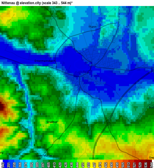
Below is the Elevation map of Nittenau, which displays elevation range with different colors. Scale of the first map is from 343 to 544 m (1125 to 1785 ft) with average elevation of 396.4 meters (=1301 ft) [note 1]
These maps also provides idea of topography and contour of this city, they are displayed at different zoom levels. More info about maps, scale and edge coordinates you can find below images.
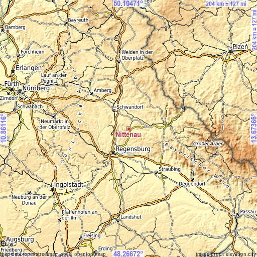
| \ | Map #1 | Map #2 | Topo.Map |
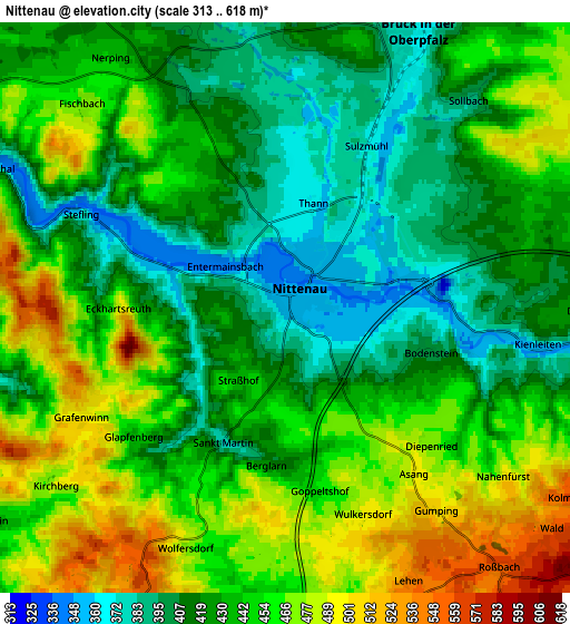
| Scale [m] | 343..544 m | 313..618 m | × |
| Scale [ft] | 1125..1785 ft | 1027..2028 ft | × |
| Average | 396.4 m = 1301 ft | 438.2 m = 1438 ft | × |
| Width | 6.39 km = 4 mi | 12.77 km = 7.9 mi | 204.4 km = 127 mi |
| Height | 6.39 km = 4 mi | 12.77 km = 7.9 mi | 204.4 km = 127 mi |
| ↑Max Latitude | 49.22296° | 49.251653° | 50.10471° |
| Latitude at center | 49.19425° | 49.19425° | 49.19425° |
| ↓Min Latitude | 49.165524° | 49.13678° | 48.26672° |
| ← Min Longitude | 12.223465° | 12.179519° | 10.86116° |
| Longitude center | 12.26741° | 12.26741° | 12.26741° |
| →Max Longitude | 12.311355° | 12.355301° | 13.67366° |
Nearby cities:
Cities around Nittenau sort by population:
• Regenstauf elevation 353 m
12.9 km,  230°
230°
• Maxhütte-Haidhof 421 m
12.7 km,  272°
272°
• Teublitz 355 m
13.5 km,  283°
283°
• Bernhardswald 453 m
11.5 km,  187°
187°
• Bruck in der Oberpfalz 371 m
6.8 km,  25°
25°
• Bodenwöhr 390 m
8.9 km,  16°
16°
• Wald 552 m
7.8 km,  129°
129°
• Tiefenbach 355 m
4.2 km,  103°
103°
• Walderbach 352 m
8.5 km, 98°
• Altenthann 498 m
10.7 km,  167°
167°
• Brunn 463 m
7.2 km,  310°
310°
• Reichenbach 372 m
6.1 km, 101°
Multilingual:
 En español:
Nittenau elevación 353 m.
 En France:
Nittenau élévation 353 m.
 Auf Deutsch:
Nittenau höhe über dem Meeresspiegel ist 353 m.

Sources and notes:
- [note 1] Map square and city borders are not equal. Map elevation data is calculated only from area inside that square.
- [src 1] Elevation data from geonames database provided with same terms of usage.
- [src 2] The elevation map of Nittenau is generated using elevation data from NASA's 3 arcsec (90m) resolution SRTM data.
- [src 3] Base (background) map © OpenStreetMap contributors tiles are generated by Geofabrik and OpenTopoMap.
Copyright & License:
This Nittenau Elevation Map is licensed under CC BY-SA. You may reuse any part from this page, if you give a proper credit by linking to this URL:
 More info on terms of use page.