Dernau elevation
Dernau (Rheinland-Pfalz), Germany elevation is 121 meters and Dernau elevation in feet is 397 ft above sea level [src 1]. Dernau is a seat of a fourth-order administrative division (feature code) with elevation that is 137 meters (449 ft) smaller than average city elevation in Germany.
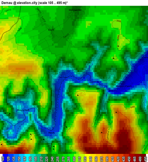
Below is the Elevation map of Dernau, which displays elevation range with different colors. Scale of the first map is from 105 to 495 m (344 to 1624 ft) with average elevation of 268.9 meters (=882 ft) [note 1]
These maps also provides idea of topography and contour of this city, they are displayed at different zoom levels. More info about maps, scale and edge coordinates you can find below images.
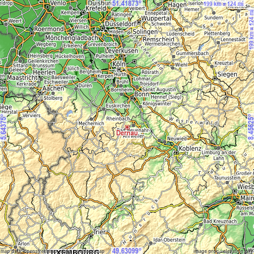
| \ | Map #1 | Topo.Map |
| Scale [m] | 105..495 m | × |
| Scale [ft] | 344..1624 ft | × |
| Average | 268.9 m = 882 ft | × |
| Width | 6.21 km = 3.9 mi | 198.8 km = 123.5 mi |
| Height | 6.21 km = 3.9 mi | 198.8 km = 123.5 mi |
| ↑Max Latitude | 50.561255° | 51.41873° |
| Latitude at center | 50.53333° | 50.53333° |
| ↓Min Latitude | 50.505389° | 49.63099° |
| ← Min Longitude | 7.006055° | 5.64375° |
| Longitude center | 7.05° | 7.05° |
| →Max Longitude | 7.093945° | 8.45625° |
Nearby cities:
Cities around Dernau sort by population:
• Bad Neuenahr-Ahrweiler elevation 101 m
4.5 km,  75°
75°
• Rheinbach 182 m
12.5 km,  325°
325°
• Meckenheim 185 m
10.2 km,  351°
351°
• Wachtberg 194 m
11.7 km,  17°
17°
• Sinzig 78 m
13.9 km,  85°
85°
• Remagen 65 m
13.5 km,  67°
67°
• Unkel 57 m
13.8 km,  59°
59°
• Kempenich 480 m
13.4 km,  159°
159°
• Altenahr 169 m
4.5 km,  246°
246°
• Berg 362 m
7.5 km,  288°
288°
• Ahrbrück 202 m
7.2 km,  217°
217°
• Niederdürenbach 302 m
13.2 km,  134°
134°
Multilingual:
 En español:
Dernau elevación 121 m.
 En France:
Dernau élévation 121 m.


Sources and notes:
- [note 1] Map square and city borders are not equal. Map elevation data is calculated only from area inside that square.
- [src 1] Elevation data from geonames database provided with same terms of usage.
- [src 2] The elevation map of Dernau is generated using elevation data from NASA's 3 arcsec (90m) resolution SRTM data.
- [src 3] Base (background) map © OpenStreetMap contributors tiles are generated by Geofabrik and OpenTopoMap.
Copyright & License:
This Dernau Elevation Map is licensed under CC BY-SA. You may reuse any part from this page, if you give a proper credit by linking to this URL:
 More info on terms of use page.