Dietfurt elevation
Dietfurt (Bavaria, Upper Palatinate), Germany elevation is 365 meters and Dietfurt elevation in feet is 1198 ft above sea level [src 1]. Dietfurt is a populated place (feature code) with elevation that is 107 meters (351 ft) bigger than average city elevation in Germany.
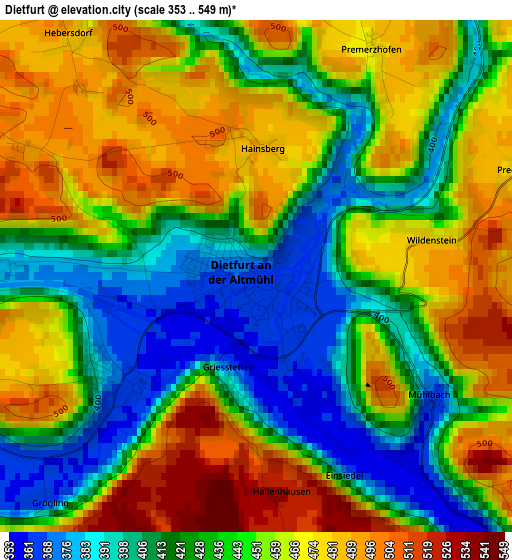
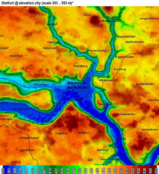
Below is the Elevation map of Dietfurt, which displays elevation range with different colors. Scale of the first map is from 353 to 549 m (1158 to 1801 ft) with average elevation of 445.4 meters (=1461 ft) [note 1]
These maps also provides idea of topography and contour of this city, they are displayed at different zoom levels. More info about maps, scale and edge coordinates you can find below images.
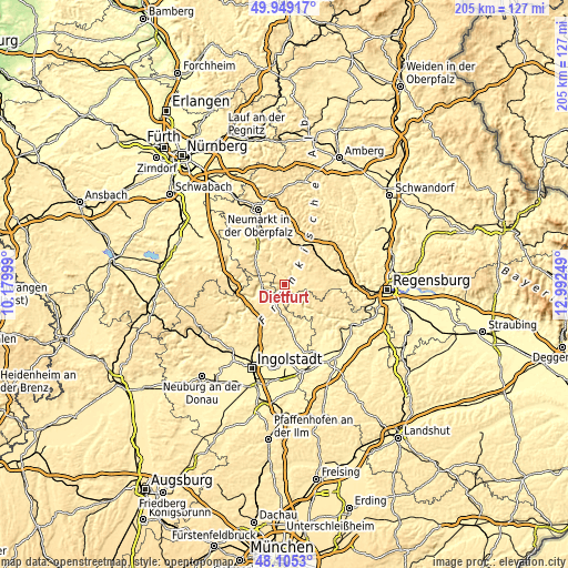
| \ | Map #1 | Map #2 | Topo.Map |
| Scale [m] | 353..549 m | 353..553 m | × |
| Scale [ft] | 1158..1801 ft | 1158..1814 ft | × |
| Average | 445.4 m = 1461 ft | 471.7 m = 1548 ft | × |
| Width | 6.41 km = 4 mi | 12.81 km = 8 mi | 205 km = 127.4 mi |
| Height | 6.41 km = 4 mi | 12.81 km = 8 mi | 205 km = 127.4 mi |
| ↑Max Latitude | 49.064582° | 49.093367° | 49.94917° |
| Latitude at center | 49.03578° | 49.03578° | 49.03578° |
| ↓Min Latitude | 49.006962° | 48.978127° | 48.1053° |
| ← Min Longitude | 11.542295° | 11.498349° | 10.17999° |
| Longitude center | 11.58624° | 11.58624° | 11.58624° |
| →Max Longitude | 11.630185° | 11.674131° | 12.99249° |
Nearby cities:
Cities around Dietfurt sort by population:
• Berching elevation 387 m
13.2 km,  306°
306°
• Hemau 510 m
14.4 km,  81°
81°
• Greding 393 m
16.8 km,  274°
274°
• Parsberg 535 m
16.9 km,  34°
34°
• Riedenburg 373 m
11 km,  136°
136°
• Beratzhausen 418 m
17.6 km,  67°
67°
• Velburg 505 m
22.7 km,  15°
15°
• Seubersdorf 515 m
14.4 km,  11°
11°
• Deining 472 m
21.4 km,  350°
350°
• Lupburg 495 m
18.2 km,  43°
43°
• Painten 507 m
17.5 km,  104°
104°
• Essing 388 m
18.6 km,  127°
127°
Multilingual:
 En español:
Dietfurt elevación 365 m.
 En France:
Dietfurt élévation 365 m.
 Auf Deutsch:
Dietfurt höhe über dem Meeresspiegel ist 365 m.

Sources and notes:
- [note 1] Map square and city borders are not equal. Map elevation data is calculated only from area inside that square.
- [src 1] Elevation data from geonames database provided with same terms of usage.
- [src 2] The elevation map of Dietfurt is generated using elevation data from NASA's 3 arcsec (90m) resolution SRTM data.
- [src 3] Base (background) map © OpenStreetMap contributors tiles are generated by Geofabrik and OpenTopoMap.
Copyright & License:
This Dietfurt Elevation Map is licensed under CC BY-SA. You may reuse any part from this page, if you give a proper credit by linking to this URL:
 More info on terms of use page.