Hemau elevation
Hemau (Bavaria, Upper Palatinate), Germany elevation is 510 meters and Hemau elevation in feet is 1673 ft above sea level [src 1]. Hemau is a populated place (feature code) with elevation that is 252 meters (827 ft) bigger than average city elevation in Germany.
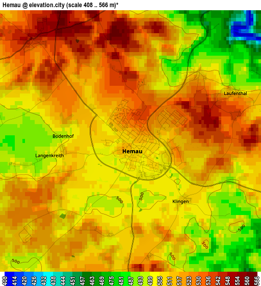
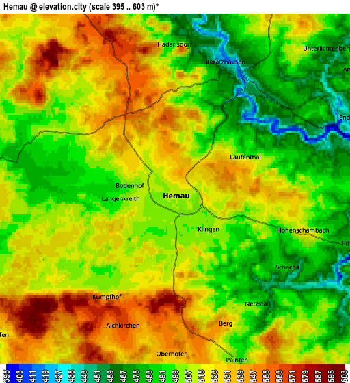
Below is the Elevation map of Hemau, which displays elevation range with different colors. Scale of the first map is from 408 to 566 m (1339 to 1857 ft) with average elevation of 511.6 meters (=1678 ft) [note 1]
These maps also provides idea of topography and contour of this city, they are displayed at different zoom levels. More info about maps, scale and edge coordinates you can find below images.
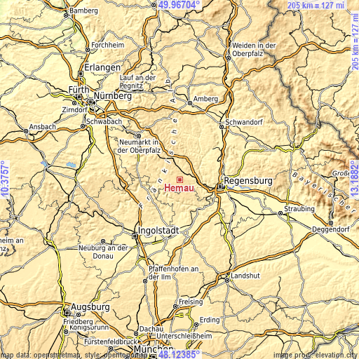
| \ | Map #1 | Map #2 | Topo.Map |
| Scale [m] | 408..566 m | 395..603 m | × |
| Scale [ft] | 1339..1857 ft | 1296..1978 ft | × |
| Average | 511.6 m = 1678 ft | 508.8 m = 1669 ft | × |
| Width | 6.4 km = 4 mi | 12.81 km = 8 mi | 204.9 km = 127.3 mi |
| Height | 6.4 km = 4 mi | 12.81 km = 8 mi | 204.9 km = 127.3 mi |
| ↑Max Latitude | 49.082781° | 49.111556° | 49.96704° |
| Latitude at center | 49.05399° | 49.05399° | 49.05399° |
| ↓Min Latitude | 49.025182° | 48.996358° | 48.12385° |
| ← Min Longitude | 11.738005° | 11.694059° | 10.3757° |
| Longitude center | 11.78195° | 11.78195° | 11.78195° |
| →Max Longitude | 11.825895° | 11.869841° | 13.1882° |
Nearby cities:
Cities around Hemau sort by population:
• Nittendorf elevation 413 m
13.5 km,  104°
104°
• Parsberg 535 m
12.7 km,  338°
338°
• Dietfurt 365 m
14.4 km,  261°
261°
• Riedenburg 373 m
12.1 km,  214°
214°
• Beratzhausen 418 m
5 km,  23°
23°
• Ihrlerstein 470 m
14.8 km,  155°
155°
• Lupburg 495 m
11.4 km,  350°
350°
• Painten 507 m
6.9 km, 156°
• Deuerling 445 m
9.5 km, 101°
• Duggendorf 472 m
12 km,  54°
54°
• Pielenhofen 346 m
12.9 km,  80°
80°
• Essing 388 m
13.3 km,  177°
177°
Multilingual:
 En español:
Hemau elevación 510 m.
 En France:
Hemau élévation 510 m.


Sources and notes:
- [note 1] Map square and city borders are not equal. Map elevation data is calculated only from area inside that square.
- [src 1] Elevation data from geonames database provided with same terms of usage.
- [src 2] The elevation map of Hemau is generated using elevation data from NASA's 3 arcsec (90m) resolution SRTM data.
- [src 3] Base (background) map © OpenStreetMap contributors tiles are generated by Geofabrik and OpenTopoMap.
Copyright & License:
This Hemau Elevation Map is licensed under CC BY-SA. You may reuse any part from this page, if you give a proper credit by linking to this URL:
 More info on terms of use page.