Deining elevation
Deining (Bavaria, Upper Palatinate), Germany elevation is 472 meters and Deining elevation in feet is 1549 ft above sea level [src 1]. Deining is a seat of a fourth-order administrative division (feature code) with elevation that is 214 meters (702 ft) bigger than average city elevation in Germany.
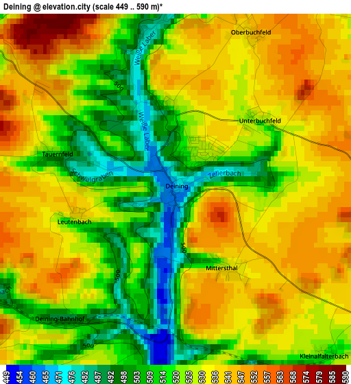
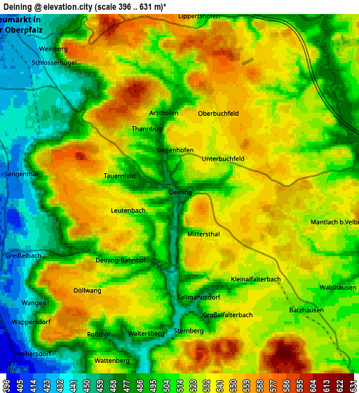
Below is the Elevation map of Deining, which displays elevation range with different colors. Scale of the first map is from 449 to 590 m (1473 to 1936 ft) with average elevation of 525.7 meters (=1725 ft) [note 1]
These maps also provides idea of topography and contour of this city, they are displayed at different zoom levels. More info about maps, scale and edge coordinates you can find below images.
| \ | Map #1 | Map #2 | Topo.Map |
| Scale [m] | 449..590 m | 396..631 m | × |
| Scale [ft] | 1473..1936 ft | 1299..2070 ft | × |
| Average | 525.7 m = 1725 ft | 514 m = 1686 ft | × |
| Width | 6.38 km = 4 mi | 12.76 km = 7.9 mi | 204.2 km = 126.9 mi |
| Height | 6.38 km = 4 mi | 12.76 km = 7.9 mi | 204.2 km = 126.9 mi |
| ↑Max Latitude | 49.254252° | 49.282927° | 50.13544° |
| Latitude at center | 49.22556° | 49.22556° | 49.22556° |
| ↓Min Latitude | 49.196852° | 49.168127° | 48.29861° |
| ← Min Longitude | 11.495735° | 11.451789° | 10.13343° |
| Longitude center | 11.53968° | 11.53968° | 11.53968° |
| →Max Longitude | 11.583625° | 11.627571° | 12.94593° |
Nearby cities:
Cities around Deining sort by population:
• Neumarkt in der Oberpfalz elevation 431 m
8.3 km,  317°
317°
• Berching 387 m
15 km,  208°
208°
• Freystadt 407 m
15.5 km,  259°
259°
• Postbauer-Heng 460 m
15.9 km,  303°
303°
• Parsberg 535 m
14.8 km,  119°
119°
• Velburg 505 m
9.6 km,  85°
85°
• Seubersdorf 515 m
9.5 km,  137°
137°
• Lauterhofen 482 m
16.5 km,  16°
16°
• Pilsach 443 m
11 km,  346°
346°
• Sengenthal 476 m
5.4 km,  279°
279°
• Berngau 431 m
10.5 km,  285°
285°
• Lupburg 495 m
17.6 km, 116°
Multilingual:
 En español:
Deining elevación 472 m.
 En France:
Deining élévation 472 m.


Sources and notes:
- [note 1] Map square and city borders are not equal. Map elevation data is calculated only from area inside that square.
- [src 1] Elevation data from geonames database provided with same terms of usage.
- [src 2] The elevation map of Deining is generated using elevation data from NASA's 3 arcsec (90m) resolution SRTM data.
- [src 3] Base (background) map © OpenStreetMap contributors tiles are generated by Geofabrik and OpenTopoMap.
Copyright & License:
This Deining Elevation Map is licensed under CC BY-SA. You may reuse any part from this page, if you give a proper credit by linking to this URL:
 More info on terms of use page.