Glött elevation
Glött (Bavaria, Swabia), Germany elevation is 437 meters and Glött elevation in feet is 1434 ft above sea level [src 1]. Glött is a seat of a fourth-order administrative division (feature code) with elevation that is 179 meters (587 ft) bigger than average city elevation in Germany.
Below is the Elevation map of Glött, which displays elevation range with different colors. Scale of the first map is from 420 to 530 m (1378 to 1739 ft) with average elevation of 461.5 meters (=1514 ft) [note 1]
These maps also provides idea of topography and contour of this city, they are displayed at different zoom levels. More info about maps, scale and edge coordinates you can find below images.
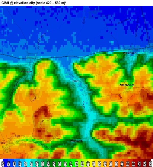
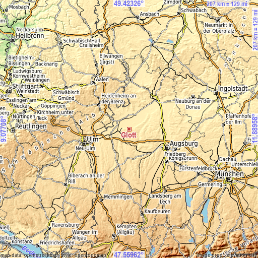
| \ | Map #1 | Topo.Map |
| Scale [m] | 420..530 m | × |
| Scale [ft] | 1378..1739 ft | × |
| Average | 461.5 m = 1514 ft | × |
| Width | 6.48 km = 4 mi | 207.2 km = 128.7 mi |
| Height | 6.48 km = 4 mi | 207.2 km = 128.7 mi |
| ↑Max Latitude | 48.529111° | 49.42326° |
| Latitude at center | 48.5° | 48.5° |
| ↓Min Latitude | 48.470873° | 47.55962° |
| ← Min Longitude | 10.439385° | 9.07708° |
| Longitude center | 10.48333° | 10.48333° |
| →Max Longitude | 10.527275° | 11.88958° |
Nearby cities:
Cities around Glött sort by population:
• Dillingen an der Donau elevation 436 m
9.1 km,  5°
5°
• Lauingen 440 m
8.6 km,  331°
331°
• Burgau 454 m
9.3 km,  215°
215°
• Offingen 448 m
9.1 km,  257°
257°
• Altenmünster 435 m
8.8 km,  116°
116°
• Holzheim 431 m
3.8 km,  65°
65°
• Roßhaupten 512 m
7.9 km,  187°
187°
• Haldenwang 474 m
7.4 km,  200°
200°
• Dürrlauingen 485 m
5.5 km,  227°
227°
• Gundremmingen 435 m
6.1 km,  270°
270°
• Aislingen 441 m
2 km,  290°
290°
• Röfingen 465 m
8.9 km, 199°
Multilingual:
 En español:
Glött elevación 437 m.
 En France:
Glött élévation 437 m.


Sources and notes:
- [note 1] Map square and city borders are not equal. Map elevation data is calculated only from area inside that square.
- [src 1] Elevation data from geonames database provided with same terms of usage.
- [src 2] The elevation map of Glött is generated using elevation data from NASA's 3 arcsec (90m) resolution SRTM data.
- [src 3] Base (background) map © OpenStreetMap contributors tiles are generated by Geofabrik and OpenTopoMap.
Copyright & License:
This Glött Elevation Map is licensed under CC BY-SA. You may reuse any part from this page, if you give a proper credit by linking to this URL:
 More info on terms of use page.