Gundremmingen elevation
Gundremmingen (Bavaria, Swabia), Germany elevation is 435 meters and Gundremmingen elevation in feet is 1427 ft above sea level [src 1]. Gundremmingen is a seat of a fourth-order administrative division (feature code) with elevation that is 177 meters (581 ft) bigger than average city elevation in Germany.
Below is the Elevation map of Gundremmingen, which displays elevation range with different colors. Scale of the first map is from 422 to 519 m (1385 to 1703 ft) with average elevation of 454.1 meters (=1490 ft) [note 1]
These maps also provides idea of topography and contour of this city, they are displayed at different zoom levels. More info about maps, scale and edge coordinates you can find below images.
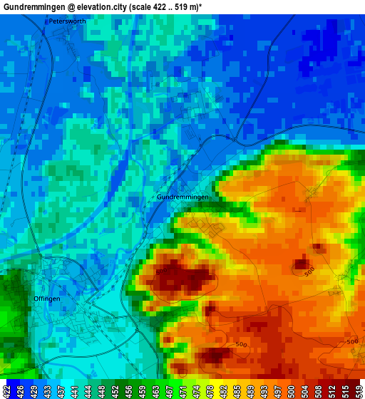
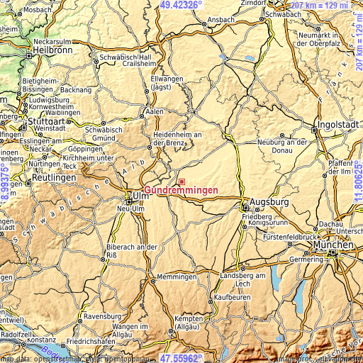
| \ | Map #1 | Topo.Map |
| Scale [m] | 422..519 m | × |
| Scale [ft] | 1385..1703 ft | × |
| Average | 454.1 m = 1490 ft | × |
| Width | 6.48 km = 4 mi | 207.2 km = 128.7 mi |
| Height | 6.48 km = 4 mi | 207.2 km = 128.7 mi |
| ↑Max Latitude | 48.529111° | 49.42326° |
| Latitude at center | 48.5° | 48.5° |
| ↓Min Latitude | 48.470873° | 47.55962° |
| ← Min Longitude | 10.356055° | 8.99375° |
| Longitude center | 10.4° | 10.4° |
| →Max Longitude | 10.443945° | 11.80625° |
Nearby cities:
Cities around Gundremmingen sort by population:
• Lauingen elevation 440 m
7.8 km,  14°
14°
• Burgau 454 m
7.6 km,  174°
174°
• Gundelfingen 439 m
6.3 km,  341°
341°
• Offingen 448 m
3.4 km,  234°
234°
• Roßhaupten 512 m
9.4 km,  147°
147°
• Haldenwang 474 m
7.8 km, 152°
• Dürrlauingen 485 m
4.3 km, 150°
• Rettenbach 500 m
5.8 km,  217°
217°
• Aislingen 441 m
4.3 km,  80°
80°
• Bächingen an der Brenz 443 m
8.2 km,  308°
308°
• Röfingen 465 m
9 km,  159°
159°
• Glött 437 m
6.1 km,  90°
90°
Multilingual:
 En español:
Gundremmingen elevación 435 m.
 En France:
Gundremmingen élévation 435 m.
 Auf Deutsch:
Gundremmingen höhe über dem Meeresspiegel ist 435 m.

Sources and notes:
- [note 1] Map square and city borders are not equal. Map elevation data is calculated only from area inside that square.
- [src 1] Elevation data from geonames database provided with same terms of usage.
- [src 2] The elevation map of Gundremmingen is generated using elevation data from NASA's 3 arcsec (90m) resolution SRTM data.
- [src 3] Base (background) map © OpenStreetMap contributors tiles are generated by Geofabrik and OpenTopoMap.
Copyright & License:
This Gundremmingen Elevation Map is licensed under CC BY-SA. You may reuse any part from this page, if you give a proper credit by linking to this URL:
 More info on terms of use page.