Burgau elevation
Burgau (Bavaria, Swabia), Germany elevation is 454 meters and Burgau elevation in feet is 1490 ft above sea level [src 1]. Burgau is a populated place (feature code) with elevation that is 196 meters (643 ft) bigger than average city elevation in Germany.
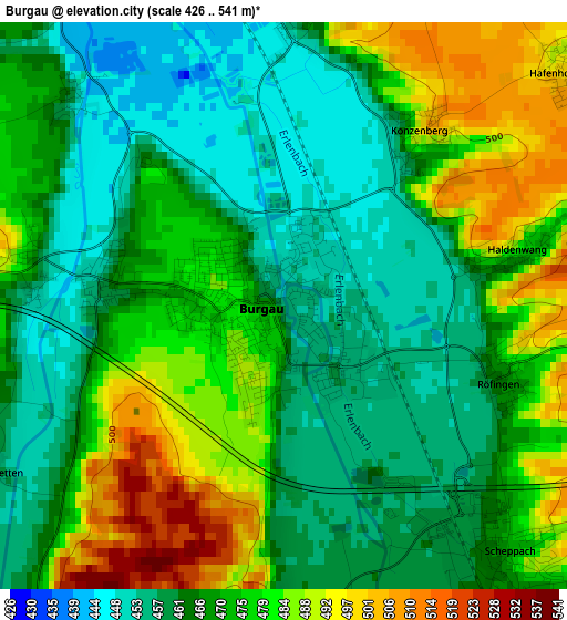
Below is the Elevation map of Burgau, which displays elevation range with different colors. Scale of the first map is from 426 to 541 m (1398 to 1775 ft) with average elevation of 470.6 meters (=1544 ft) [note 1]
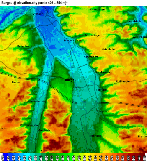
These maps also provides idea of topography and contour of this city, they are displayed at different zoom levels. More info about maps, scale and edge coordinates you can find below images.
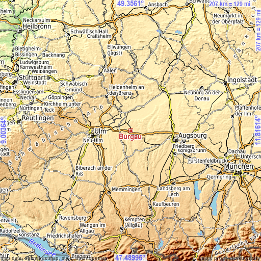
| \ | Map #1 | Map #2 | Topo.Map |
| Scale [m] | 426..541 m | 426..554 m | × |
| Scale [ft] | 1398..1775 ft | 1398..1818 ft | × |
| Average | 470.6 m = 1544 ft | 487.5 m = 1599 ft | × |
| Width | 6.48 km = 4 mi | 12.97 km = 8.1 mi | 207.5 km = 128.9 mi |
| Height | 6.48 km = 4 mi | 12.97 km = 8.1 mi | 207.5 km = 128.9 mi |
| ↑Max Latitude | 48.46074° | 48.489873° | 49.3561° |
| Latitude at center | 48.43159° | 48.43159° | 48.43159° |
| ↓Min Latitude | 48.402423° | 48.37324° | 47.48995° |
| ← Min Longitude | 10.365945° | 10.321999° | 9.00364° |
| Longitude center | 10.40989° | 10.40989° | 10.40989° |
| →Max Longitude | 10.453835° | 10.497781° | 11.81614° |
Nearby cities:
Cities around Burgau sort by population:
• Günzburg elevation 470 m
10.2 km,  285°
285°
• Ichenhausen 492 m
10.1 km,  228°
228°
• Jettingen-Scheppach 472 m
5.1 km,  155°
155°
• Offingen 448 m
6.7 km,  328°
328°
• Roßhaupten 512 m
4.4 km,  93°
93°
• Haldenwang 474 m
2.9 km,  76°
76°
• Dürrlauingen 485 m
4.1 km,  19°
19°
• Rettenbach 500 m
5.2 km,  305°
305°
• Gundremmingen 435 m
7.6 km,  354°
354°
• Aislingen 441 m
9 km, 22°
• Röfingen 465 m
2.5 km,  108°
108°
• Glött 437 m
9.3 km,  35°
35°
Multilingual:
 En español:
Burgau elevación 454 m.
 En France:
Burgau élévation 454 m.


Sources and notes:
- [note 1] Map square and city borders are not equal. Map elevation data is calculated only from area inside that square.
- [src 1] Elevation data from geonames database provided with same terms of usage.
- [src 2] The elevation map of Burgau is generated using elevation data from NASA's 3 arcsec (90m) resolution SRTM data.
- [src 3] Base (background) map © OpenStreetMap contributors tiles are generated by Geofabrik and OpenTopoMap.
Copyright & License:
This Burgau Elevation Map is licensed under CC BY-SA. You may reuse any part from this page, if you give a proper credit by linking to this URL:
 More info on terms of use page.