Gumtow elevation
Gumtow (Brandenburg), Germany elevation is 58 meters and Gumtow elevation in feet is 190 ft above sea level [src 1]. Gumtow is a seat of a fourth-order administrative division (feature code) with elevation that is 200 meters (656 ft) smaller than average city elevation in Germany.
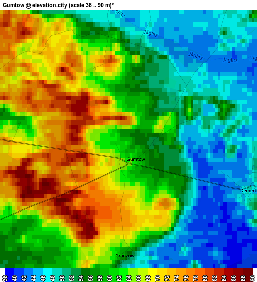
Below is the Elevation map of Gumtow, which displays elevation range with different colors. Scale of the first map is from 38 to 90 m (125 to 295 ft) with average elevation of 59.4 meters (=195 ft) [note 1]
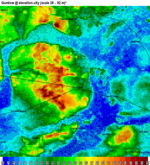
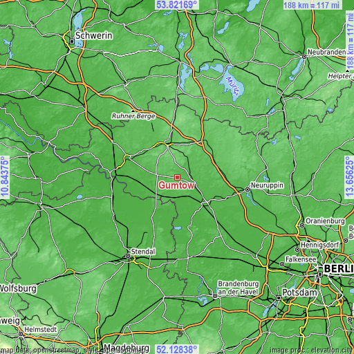
These maps also provides idea of topography and contour of this city, they are displayed at different zoom levels. More info about maps, scale and edge coordinates you can find below images.
| \ | Map #1 | Map #2 | Topo.Map |
| Scale [m] | 38..90 m | 38..92 m | × |
| Scale [ft] | 125..295 ft | 125..302 ft | × |
| Average | 59.4 m = 195 ft | 54.2 m = 178 ft | × |
| Width | 5.88 km = 3.7 mi | 11.77 km = 7.3 mi | 188.3 km = 117 mi |
| Height | 5.88 km = 3.7 mi | 11.77 km = 7.3 mi | 188.3 km = 117 mi |
| ↑Max Latitude | 53.009779° | 53.036212° | 53.82169° |
| Latitude at center | 52.98333° | 52.98333° | 52.98333° |
| ↓Min Latitude | 52.956865° | 52.930383° | 52.12838° |
| ← Min Longitude | 12.206055° | 12.162109° | 10.84375° |
| Longitude center | 12.25° | 12.25° | 12.25° |
| →Max Longitude | 12.293945° | 12.337891° | 13.65625° |
Nearby cities:
Cities around Gumtow sort by population:
• Wittstock elevation 66 m
25.2 km,  38°
38°
• Pritzwalk 63 m
19.2 km,  344°
344°
• Kyritz 45 m
10.9 km,  114°
114°
• Havelberg 44 m
20.6 km,  214°
214°
• Wusterhausen 36 m
17.4 km,  126°
126°
• Groß Pankow 57 m
20.2 km,  318°
318°
• Heiligengrabe 79 m
19.4 km,  22°
22°
• Plattenburg 33 m
15 km,  259°
259°
• Bad Wilsnack 27 m
20.4 km, 261°
• Dreetz 29 m
24.5 km,  144°
144°
• Sandau 31 m
25.5 km, 212°
• Breddin 44 m
11 km,  189°
189°
Multilingual:
 En español:
Gumtow elevación 58 m.
 En France:
Gumtow élévation 58 m.


Sources and notes:
- [note 1] Map square and city borders are not equal. Map elevation data is calculated only from area inside that square.
- [src 1] Elevation data from geonames database provided with same terms of usage.
- [src 2] The elevation map of Gumtow is generated using elevation data from NASA's 3 arcsec (90m) resolution SRTM data.
- [src 3] Base (background) map © OpenStreetMap contributors tiles are generated by Geofabrik and OpenTopoMap.
Copyright & License:
This Gumtow Elevation Map is licensed under CC BY-SA. You may reuse any part from this page, if you give a proper credit by linking to this URL:
 More info on terms of use page.