Kyritz elevation
Kyritz (Brandenburg), Germany elevation is 45 meters and Kyritz elevation in feet is 148 ft above sea level [src 1]. Kyritz is a populated place (feature code) with elevation that is 213 meters (699 ft) smaller than average city elevation in Germany.
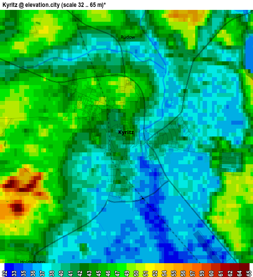
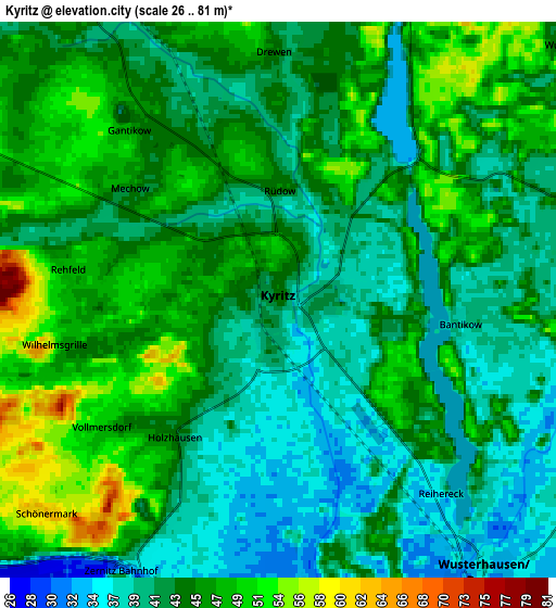
Below is the Elevation map of Kyritz, which displays elevation range with different colors. Scale of the first map is from 32 to 65 m (105 to 213 ft) with average elevation of 42.3 meters (=139 ft) [note 1]
These maps also provides idea of topography and contour of this city, they are displayed at different zoom levels. More info about maps, scale and edge coordinates you can find below images.
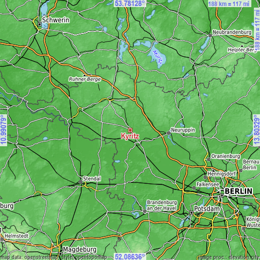
| \ | Map #1 | Map #2 | Topo.Map |
| Scale [m] | 32..65 m | 26..81 m | × |
| Scale [ft] | 105..213 ft | 85..266 ft | × |
| Average | 42.3 m = 139 ft | 43.8 m = 144 ft | × |
| Width | 5.89 km = 3.7 mi | 11.78 km = 7.3 mi | 188.5 km = 117.1 mi |
| Height | 5.89 km = 3.7 mi | 11.78 km = 7.3 mi | 188.4 km = 117.1 mi |
| ↑Max Latitude | 52.968594° | 52.995052° | 53.78128° |
| Latitude at center | 52.94212° | 52.94212° | 52.94212° |
| ↓Min Latitude | 52.91563° | 52.889123° | 52.08636° |
| ← Min Longitude | 12.353095° | 12.309149° | 10.99079° |
| Longitude center | 12.39704° | 12.39704° | 12.39704° |
| →Max Longitude | 12.440985° | 12.484931° | 13.80329° |
Nearby cities:
Cities around Kyritz sort by population:
• Neuruppin elevation 45 m
27.3 km,  93°
93°
• Wittstock 66 m
25 km,  13°
13°
• Pritzwalk 63 m
27.5 km,  327°
327°
• Havelberg 44 m
24.9 km,  240°
240°
• Wusterhausen 36 m
7.1 km,  143°
143°
• Heiligengrabe 79 m
22.6 km,  354°
354°
• Gumtow 58 m
10.9 km,  294°
294°
• Plattenburg 33 m
24.7 km,  274°
274°
• Friesack 34 m
25.8 km,  151°
151°
• Rhinow 30 m
21.6 km,  189°
189°
• Dreetz 29 m
16 km,  164°
164°
• Breddin 44 m
13.2 km, 241°
Multilingual:
 En español:
Kyritz elevación 45 m.
 En France:
Kyritz élévation 45 m.


Sources and notes:
- [note 1] Map square and city borders are not equal. Map elevation data is calculated only from area inside that square.
- [src 1] Elevation data from geonames database provided with same terms of usage.
- [src 2] The elevation map of Kyritz is generated using elevation data from NASA's 3 arcsec (90m) resolution SRTM data.
- [src 3] Base (background) map © OpenStreetMap contributors tiles are generated by Geofabrik and OpenTopoMap.
Copyright & License:
This Kyritz Elevation Map is licensed under CC BY-SA. You may reuse any part from this page, if you give a proper credit by linking to this URL:
 More info on terms of use page.