Hameln elevation
Hameln (Lower Saxony), Germany elevation is 74 meters and Hameln elevation in feet is 243 ft above sea level [src 1]. Hameln is a seat of a third-order administrative division (feature code) with elevation that is 184 meters (604 ft) smaller than average city elevation in Germany.
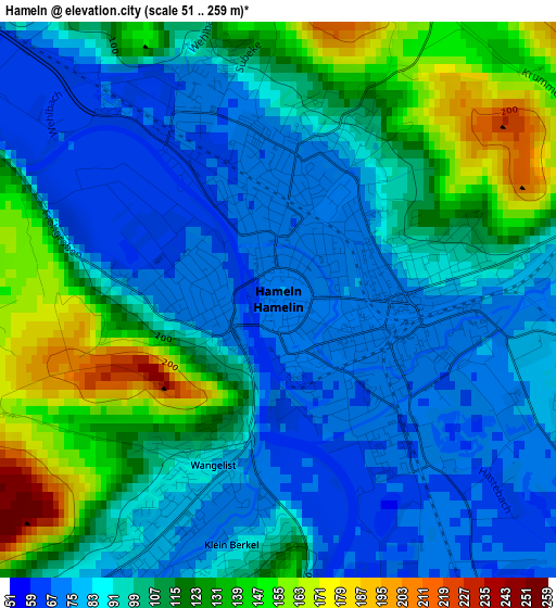
Below is the Elevation map of Hameln, which displays elevation range with different colors. Scale of the first map is from 51 to 259 m (167 to 850 ft) with average elevation of 101.6 meters (=333 ft) [note 1]
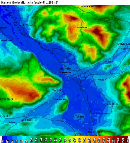
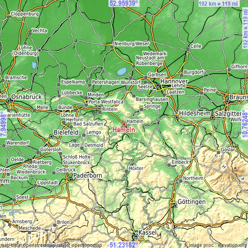
These maps also provides idea of topography and contour of this city, they are displayed at different zoom levels. More info about maps, scale and edge coordinates you can find below images.
| \ | Map #1 | Map #2 | Topo.Map |
| Scale [m] | 51..259 m | 51..288 m | × |
| Scale [ft] | 167..850 ft | 167..945 ft | × |
| Average | 101.6 m = 333 ft | 116 m = 381 ft | × |
| Width | 6 km = 3.7 mi | 12.01 km = 7.5 mi | 192.1 km = 119.4 mi |
| Height | 6 km = 3.7 mi | 12.01 km = 7.5 mi | 192.1 km = 119.4 mi |
| ↑Max Latitude | 52.130954° | 52.157922° | 52.95939° |
| Latitude at center | 52.10397° | 52.10397° | 52.10397° |
| ↓Min Latitude | 52.076969° | 52.049952° | 51.23182° |
| ← Min Longitude | 9.312285° | 9.268339° | 7.94998° |
| Longitude center | 9.35623° | 9.35623° | 9.35623° |
| →Max Longitude | 9.400175° | 9.444121° | 10.76248° |
Nearby cities:
Cities around Hameln sort by population:
• Springe elevation 110 m
17.8 km,  49°
49°
• Bad Pyrmont 113 m
14.9 km,  208°
208°
• Hessisch Oldendorf 68 m
10.6 km,  316°
316°
• Bad Münder am Deister 118 m
12.6 km,  35°
35°
• Lügde 106 m
17.8 km,  204°
204°
• Aerzen 105 m
9 km,  227°
227°
• Salzhemmendorf 119 m
16.3 km,  104°
104°
• Coppenbrügge 136 m
13.2 km,  82°
82°
• Bodenwerder 95 m
18.5 km,  142°
142°
• Hehlen 73 m
15 km,  148°
148°
• Ottenstein 290 m
17.8 km,  168°
168°
• Hülsede 109 m
16.2 km,  1°
1°
Multilingual:
 En español:
Hamelín elevación 74 m.
 En France:
Hamelin élévation 74 m.


Sources and notes:
- [note 1] Map square and city borders are not equal. Map elevation data is calculated only from area inside that square.
- [src 1] Elevation data from geonames database provided with same terms of usage.
- [src 2] The elevation map of Hameln is generated using elevation data from NASA's 3 arcsec (90m) resolution SRTM data.
- [src 3] Base (background) map © OpenStreetMap contributors tiles are generated by Geofabrik and OpenTopoMap.
Copyright & License:
This Hameln Elevation Map is licensed under CC BY-SA. You may reuse any part from this page, if you give a proper credit by linking to this URL:
 More info on terms of use page.