Hoyerswerda elevation
Hoyerswerda (Saxony), Germany elevation is 118 meters and Hoyerswerda elevation in feet is 387 ft above sea level [src 1]. Hoyerswerda is a populated place (feature code) with elevation that is 140 meters (459 ft) smaller than average city elevation in Germany.
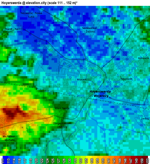
Below is the Elevation map of Hoyerswerda, which displays elevation range with different colors. Scale of the first map is from 111 to 152 m (364 to 499 ft) with average elevation of 120.2 meters (=394 ft) [note 1]
These maps also provides idea of topography and contour of this city, they are displayed at different zoom levels. More info about maps, scale and edge coordinates you can find below images.
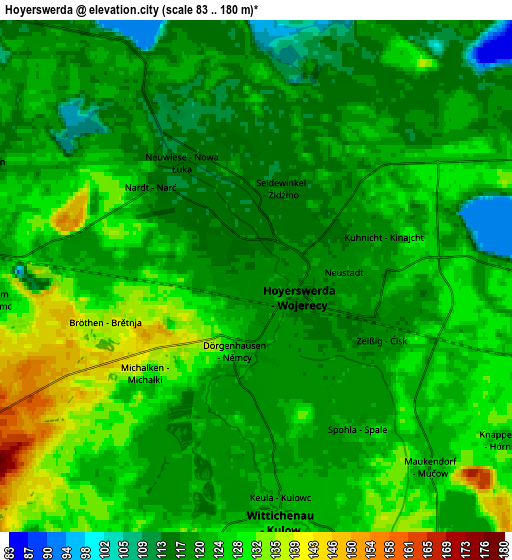
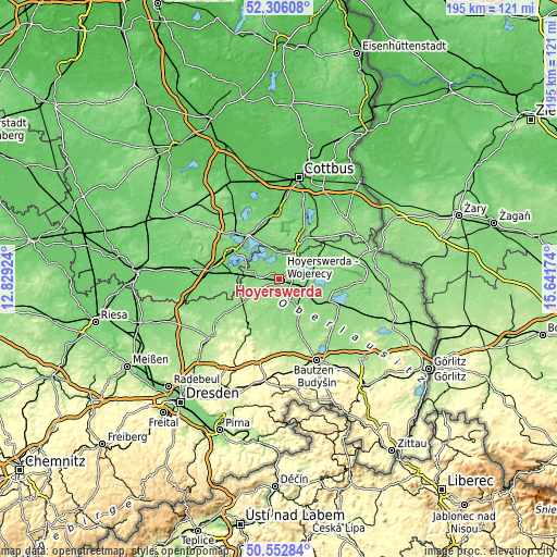
| \ | Map #1 | Map #2 | Topo.Map |
| Scale [m] | 111..152 m | 83..180 m | × |
| Scale [ft] | 364..499 ft | 272..591 ft | × |
| Average | 120.2 m = 394 ft | 122.8 m = 403 ft | × |
| Width | 6.09 km = 3.8 mi | 12.18 km = 7.6 mi | 194.9 km = 121.1 mi |
| Height | 6.09 km = 3.8 mi | 12.18 km = 7.6 mi | 194.9 km = 121.1 mi |
| ↑Max Latitude | 51.465256° | 51.492625° | 52.30608° |
| Latitude at center | 51.43787° | 51.43787° | 51.43787° |
| ↓Min Latitude | 51.410468° | 51.383049° | 50.55284° |
| ← Min Longitude | 14.191545° | 14.147599° | 12.82924° |
| Longitude center | 14.23549° | 14.23549° | 14.23549° |
| →Max Longitude | 14.279435° | 14.323381° | 15.64174° |
Nearby cities:
Cities around Hoyerswerda sort by population:
• Senftenberg elevation 104 m
18.9 km,  300°
300°
• Wittichenau 126 m
5.9 km,  174°
174°
• Bernsdorf 148 m
13.6 km,  238°
238°
• Lohsa 127 m
12.9 km,  117°
117°
• Welzow 125 m
16.8 km,  344°
344°
• Königswartha 144 m
15.6 km,  155°
155°
• Neschwitz 151 m
19.7 km, 160°
• Oßling 164 m
9.9 km,  209°
209°
• Horka 167 m
19.4 km,  175°
175°
• Nebelschütz 170 m
20.2 km,  195°
195°
• Hohenbocka 131 m
15.7 km,  267°
267°
• Wiednitz 137 m
15.6 km,  248°
248°
Multilingual:
 En español:
Hoyerswerda elevación 118 m.
 En France:
Hoyerswerda élévation 118 m.
 Auf Deutsch:
Hoyerswerda höhe über dem Meeresspiegel ist 118 m.

Sources and notes:
- [note 1] Map square and city borders are not equal. Map elevation data is calculated only from area inside that square.
- [src 1] Elevation data from geonames database provided with same terms of usage.
- [src 2] The elevation map of Hoyerswerda is generated using elevation data from NASA's 3 arcsec (90m) resolution SRTM data.
- [src 3] Base (background) map © OpenStreetMap contributors tiles are generated by Geofabrik and OpenTopoMap.
Copyright & License:
This Hoyerswerda Elevation Map is licensed under CC BY-SA. You may reuse any part from this page, if you give a proper credit by linking to this URL:
 More info on terms of use page.