Mittenwald elevation
Mittenwald (Bavaria, Upper Bavaria), Germany elevation is 915 meters and Mittenwald elevation in feet is 3002 ft above sea level [src 1]. Mittenwald is a populated place (feature code) with elevation that is 657 meters (2156 ft) bigger than average city elevation in Germany.
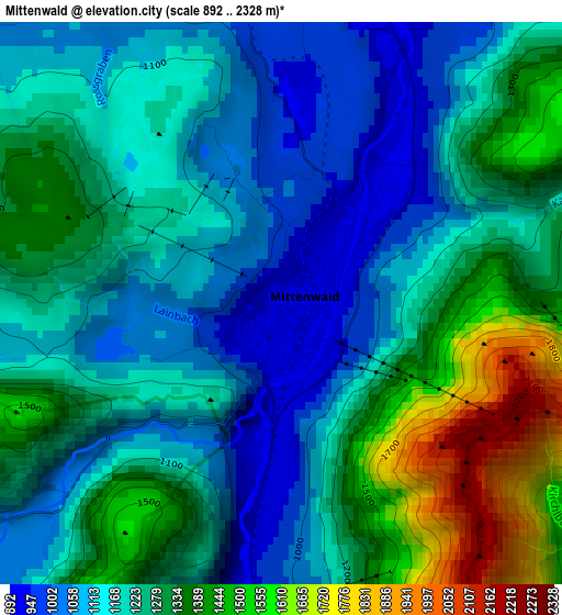
Below is the Elevation map of Mittenwald, which displays elevation range with different colors. Scale of the first map is from 892 to 2328 m (2927 to 7638 ft) with average elevation of 1232.3 meters (=4043 ft) [note 1]
These maps also provides idea of topography and contour of this city, they are displayed at different zoom levels. More info about maps, scale and edge coordinates you can find below images.
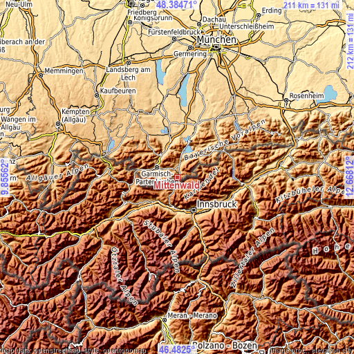
| \ | Map #1 | Map #2 | Topo.Map |
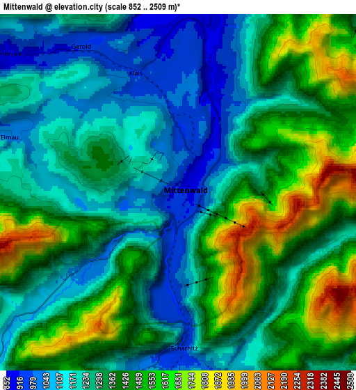
| Scale [m] | 892..2328 m | 852..2509 m | × |
| Scale [ft] | 2927..7638 ft | 2795..8232 ft | × |
| Average | 1232.3 m = 4043 ft | 1326.6 m = 4352 ft | × |
| Width | 6.61 km = 4.1 mi | 13.22 km = 8.2 mi | 211.5 km = 131.4 mi |
| Height | 6.61 km = 4.1 mi | 13.22 km = 8.2 mi | 211.5 km = 131.4 mi |
| ↑Max Latitude | 47.471913° | 47.50161° | 48.38471° |
| Latitude at center | 47.4422° | 47.4422° | 47.4422° |
| ↓Min Latitude | 47.41247° | 47.382723° | 46.4825° |
| ← Min Longitude | 11.217925° | 11.173979° | 9.85562° |
| Longitude center | 11.26187° | 11.26187° | 11.26187° |
| →Max Longitude | 11.305815° | 11.349761° | 12.66812° |
Nearby cities:
Cities around Mittenwald sort by population:
• Garmisch-Partenkirchen elevation 705 m
13.7 km,  293°
293°
• Murnau am Staffelsee 698 m
26.9 km,  350°
350°
• Oberammergau 840 m
22.7 km,  319°
319°
• Kochel 611 m
25.4 km,  18°
18°
• Farchant 671 m
15 km,  310°
310°
• Grainau 749 m
18.3 km,  281°
281°
• Ohlstadt 669 m
21.4 km, 354°
• Krün 877 m
7.1 km,  10°
10°
• Wallgau 865 m
8.4 km, 11°
• Unterammergau 837 m
26.2 km, 317°
• Großweil 625 m
26.2 km, 6°
• Schlehdorf 605 m
24.3 km, 9°
Multilingual:
 En español:
Mittenwald elevación 915 m.
 En France:
Mittenwald élévation 915 m.
 Auf Deutsch:
Mittenwald höhe über dem Meeresspiegel ist 915 m.

Sources and notes:
- [note 1] Map square and city borders are not equal. Map elevation data is calculated only from area inside that square.
- [src 1] Elevation data from geonames database provided with same terms of usage.
- [src 2] The elevation map of Mittenwald is generated using elevation data from NASA's 3 arcsec (90m) resolution SRTM data.
- [src 3] Base (background) map © OpenStreetMap contributors tiles are generated by Geofabrik and OpenTopoMap.
Copyright & License:
This Mittenwald Elevation Map is licensed under CC BY-SA. You may reuse any part from this page, if you give a proper credit by linking to this URL:
 More info on terms of use page.