Farchant elevation
Farchant (Bavaria, Upper Bavaria), Germany elevation is 671 meters and Farchant elevation in feet is 2201 ft above sea level [src 1]. Farchant is a seat of a fourth-order administrative division (feature code) with elevation that is 413 meters (1355 ft) bigger than average city elevation in Germany.
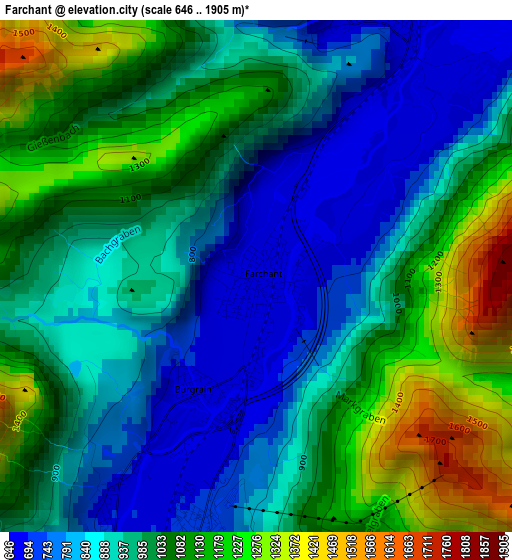
Below is the Elevation map of Farchant, which displays elevation range with different colors. Scale of the first map is from 646 to 1905 m (2119 to 6250 ft) with average elevation of 981.8 meters (=3221 ft) [note 1]
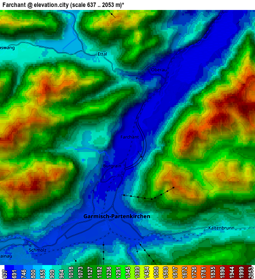
These maps also provides idea of topography and contour of this city, they are displayed at different zoom levels. More info about maps, scale and edge coordinates you can find below images.
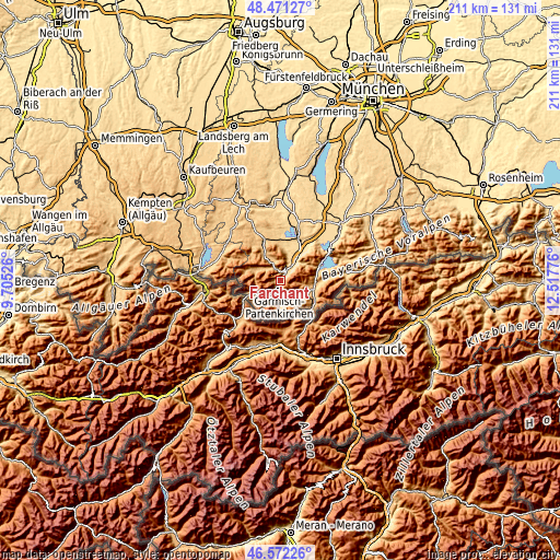
| \ | Map #1 | Map #2 | Topo.Map |
| Scale [m] | 646..1905 m | 637..2053 m | × |
| Scale [ft] | 2119..6250 ft | 2090..6736 ft | × |
| Average | 981.8 m = 3221 ft | 1085.1 m = 3560 ft | × |
| Width | 6.6 km = 4.1 mi | 13.2 km = 8.2 mi | 211.2 km = 131.2 mi |
| Height | 6.6 km = 4.1 mi | 13.2 km = 8.2 mi | 211.1 km = 131.2 mi |
| ↑Max Latitude | 47.560023° | 47.58967° | 48.47127° |
| Latitude at center | 47.53036° | 47.53036° | 47.53036° |
| ↓Min Latitude | 47.50068° | 47.470983° | 46.57226° |
| ← Min Longitude | 11.067565° | 11.023619° | 9.70526° |
| Longitude center | 11.11151° | 11.11151° | 11.11151° |
| →Max Longitude | 11.155455° | 11.199401° | 12.51776° |
Nearby cities:
Cities around Farchant sort by population:
• Garmisch-Partenkirchen elevation 705 m
4.4 km,  195°
195°
• Murnau am Staffelsee 698 m
18 km,  21°
21°
• Mittenwald 915 m
15 km,  130°
130°
• Oberammergau 840 m
8.2 km,  336°
336°
• Grainau 749 m
8.9 km,  227°
227°
• Ohlstadt 669 m
14.6 km,  38°
38°
• Seehausen am Staffelsee 658 m
18.5 km, 17°
• Bad Kohlgrub 828 m
15.8 km, 343°
• Krün 877 m
12.9 km,  102°
102°
• Saulgrub 860 m
16.5 km, 336°
• Wallgau 865 m
13 km, 96°
• Unterammergau 837 m
11.5 km,  326°
326°
Multilingual:
 En español:
Farchant elevación 671 m.
 En France:
Farchant élévation 671 m.
 Auf Deutsch:
Farchant höhe über dem Meeresspiegel ist 671 m.

Sources and notes:
- [note 1] Map square and city borders are not equal. Map elevation data is calculated only from area inside that square.
- [src 1] Elevation data from geonames database provided with same terms of usage.
- [src 2] The elevation map of Farchant is generated using elevation data from NASA's 3 arcsec (90m) resolution SRTM data.
- [src 3] Base (background) map © OpenStreetMap contributors tiles are generated by Geofabrik and OpenTopoMap.
Copyright & License:
This Farchant Elevation Map is licensed under CC BY-SA. You may reuse any part from this page, if you give a proper credit by linking to this URL:
 More info on terms of use page.