Wallgau elevation
Wallgau (Bavaria, Upper Bavaria), Germany elevation is 865 meters and Wallgau elevation in feet is 2838 ft above sea level [src 1]. Wallgau is a seat of a fourth-order administrative division (feature code) with elevation that is 607 meters (1991 ft) bigger than average city elevation in Germany.
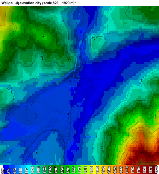
Below is the Elevation map of Wallgau, which displays elevation range with different colors. Scale of the first map is from 829 to 1920 m (2720 to 6299 ft) with average elevation of 1044.7 meters (=3427 ft) [note 1]
These maps also provides idea of topography and contour of this city, they are displayed at different zoom levels. More info about maps, scale and edge coordinates you can find below images.
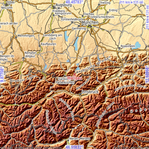
| \ | Map #1 | Topo.Map |
| Scale [m] | 829..1920 m | × |
| Scale [ft] | 2720..6299 ft | × |
| Average | 1044.7 m = 3427 ft | × |
| Width | 6.6 km = 4.1 mi | 211.2 km = 131.2 mi |
| Height | 6.6 km = 4.1 mi | 211.2 km = 131.2 mi |
| ↑Max Latitude | 47.546341° | 48.45783° |
| Latitude at center | 47.51667° | 47.51667° |
| ↓Min Latitude | 47.486982° | 46.55832° |
| ← Min Longitude | 11.239385° | 9.87708° |
| Longitude center | 11.28333° | 11.28333° |
| →Max Longitude | 11.327275° | 12.68958° |
Nearby cities:
Cities around Wallgau sort by population:
• Garmisch-Partenkirchen elevation 705 m
14.4 km,  259°
259°
• Murnau am Staffelsee 698 m
19.3 km,  341°
341°
• Mittenwald 915 m
8.4 km,  191°
191°
• Oberammergau 840 m
18.6 km,  299°
299°
• Kochel 611 m
17.1 km,  21°
21°
• Farchant 671 m
13 km,  276°
276°
• Grainau 749 m
20 km, 256°
• Ohlstadt 669 m
13.5 km, 343°
• Seehausen am Staffelsee 658 m
20.6 km, 338°
• Krün 877 m
1.3 km, 193°
• Großweil 625 m
17.8 km,  4°
4°
• Schlehdorf 605 m
15.9 km,  8°
8°
Multilingual:
 En español:
Wallgau elevación 865 m.
 En France:
Wallgau élévation 865 m.


Sources and notes:
- [note 1] Map square and city borders are not equal. Map elevation data is calculated only from area inside that square.
- [src 1] Elevation data from geonames database provided with same terms of usage.
- [src 2] The elevation map of Wallgau is generated using elevation data from NASA's 3 arcsec (90m) resolution SRTM data.
- [src 3] Base (background) map © OpenStreetMap contributors tiles are generated by Geofabrik and OpenTopoMap.
Copyright & License:
This Wallgau Elevation Map is licensed under CC BY-SA. You may reuse any part from this page, if you give a proper credit by linking to this URL:
 More info on terms of use page.