Kochel elevation
Kochel (Bavaria, Upper Bavaria), Germany elevation is 611 meters and Kochel elevation in feet is 2005 ft above sea level [src 1]. Kochel is a populated place (feature code) with elevation that is 353 meters (1158 ft) bigger than average city elevation in Germany.
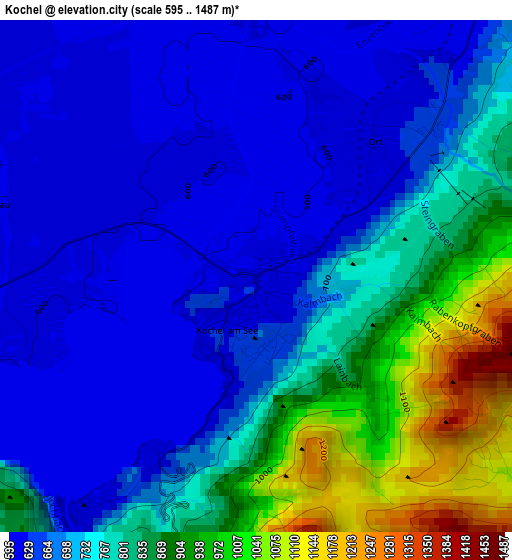
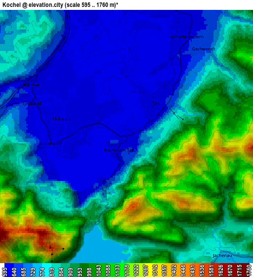
Below is the Elevation map of Kochel, which displays elevation range with different colors. Scale of the first map is from 595 to 1487 m (1952 to 4879 ft) with average elevation of 743.5 meters (=2439 ft) [note 1]
These maps also provides idea of topography and contour of this city, they are displayed at different zoom levels. More info about maps, scale and edge coordinates you can find below images.
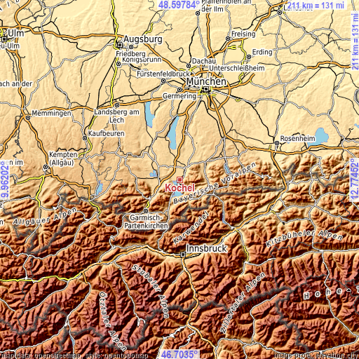
| \ | Map #1 | Map #2 | Topo.Map |
| Scale [m] | 595..1487 m | 595..1760 m | × |
| Scale [ft] | 1952..4879 ft | 1952..5774 ft | × |
| Average | 743.5 m = 2439 ft | 847.2 m = 2780 ft | × |
| Width | 6.58 km = 4.1 mi | 13.16 km = 8.2 mi | 210.6 km = 130.9 mi |
| Height | 6.58 km = 4.1 mi | 13.16 km = 8.2 mi | 210.6 km = 130.9 mi |
| ↑Max Latitude | 47.68885° | 47.718424° | 48.59784° |
| Latitude at center | 47.65926° | 47.65926° | 47.65926° |
| ↓Min Latitude | 47.629653° | 47.600029° | 46.7035° |
| ← Min Longitude | 11.324325° | 11.280379° | 9.96202° |
| Longitude center | 11.36827° | 11.36827° | 11.36827° |
| →Max Longitude | 11.412215° | 11.456161° | 12.77452° |
Nearby cities:
Cities around Kochel sort by population:
• Penzberg elevation 600 m
10.4 km,  3°
3°
• Bad Heilbrunn 681 m
11.9 km,  35°
35°
• Benediktbeuern 639 m
6.3 km,  33°
33°
• Ohlstadt 669 m
10.5 km,  254°
254°
• Iffeldorf 608 m
12.6 km,  342°
342°
• Bichl 625 m
7.5 km, 25°
• Großweil 625 m
5.4 km,  290°
290°
• Schlehdorf 605 m
4 km,  267°
267°
• Riegsee 662 m
11 km, 293°
• Habach 646 m
10.4 km,  322°
322°
• Antdorf 624 m
11.2 km, 336°
• Sindelsdorf 612 m
7.7 km, 340°
Multilingual:
 En español:
Kochel elevación 611 m.
 En France:
Kochel élévation 611 m.


Sources and notes:
- [note 1] Map square and city borders are not equal. Map elevation data is calculated only from area inside that square.
- [src 1] Elevation data from geonames database provided with same terms of usage.
- [src 2] The elevation map of Kochel is generated using elevation data from NASA's 3 arcsec (90m) resolution SRTM data.
- [src 3] Base (background) map © OpenStreetMap contributors tiles are generated by Geofabrik and OpenTopoMap.
Copyright & License:
This Kochel Elevation Map is licensed under CC BY-SA. You may reuse any part from this page, if you give a proper credit by linking to this URL:
 More info on terms of use page.