Mudau elevation
Mudau (Baden-Württemberg, Karlsruhe Region), Germany elevation is 452 meters and Mudau elevation in feet is 1483 ft above sea level [src 1]. Mudau is a seat of a fourth-order administrative division (feature code) with elevation that is 194 meters (636 ft) bigger than average city elevation in Germany.
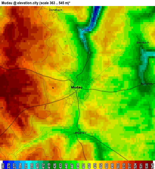
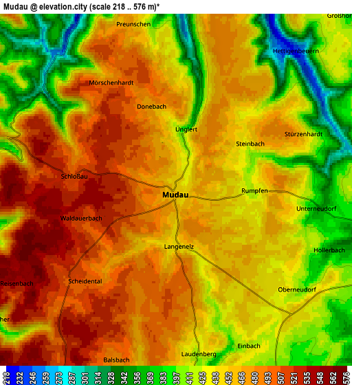
Below is the Elevation map of Mudau, which displays elevation range with different colors. Scale of the first map is from 363 to 545 m (1191 to 1788 ft) with average elevation of 475.3 meters (=1559 ft) [note 1]
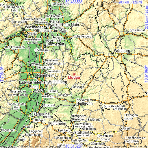
These maps also provides idea of topography and contour of this city, they are displayed at different zoom levels. More info about maps, scale and edge coordinates you can find below images.
| \ | Map #1 | Map #2 | Topo.Map |
| Scale [m] | 363..545 m | 218..576 m | × |
| Scale [ft] | 1191..1788 ft | 715..1890 ft | × |
| Average | 475.3 m = 1559 ft | 451.9 m = 1483 ft | × |
| Width | 6.34 km = 3.9 mi | 12.68 km = 7.9 mi | 203 km = 126.1 mi |
| Height | 6.34 km = 3.9 mi | 12.68 km = 7.9 mi | 202.9 km = 126.1 mi |
| ↑Max Latitude | 49.562952° | 49.591447° | 50.43858° |
| Latitude at center | 49.53444° | 49.53444° | 49.53444° |
| ↓Min Latitude | 49.505912° | 49.477367° | 48.61326° |
| ← Min Longitude | 9.160495° | 9.116549° | 7.79819° |
| Longitude center | 9.20444° | 9.20444° | 9.20444° |
| →Max Longitude | 9.248385° | 9.292331° | 10.61069° |
Nearby cities:
Cities around Mudau sort by population:
• Buchen in Odenwald elevation 344 m
8.6 km,  97°
97°
• Eberbach 144 m
17.2 km,  244°
244°
• Walldürn 417 m
12.9 km,  64°
64°
• Miltenberg 145 m
19.4 km,  13°
13°
• Beerfelden 414 m
17 km,  282°
282°
• Osterburken 250 m
19.6 km,  126°
126°
• Seckach 269 m
13.9 km,  137°
137°
• Höpfingen 383 m
17.8 km, 64°
• Fahrenbach 367 m
12.1 km,  198°
198°
• Kirchzell 197 m
9.5 km,  348°
348°
• Neckargerach 133 m
18 km,  213°
213°
• Weilbach 152 m
14.9 km,  3°
3°
Multilingual:
 En español:
Mudau elevación 452 m.
 En France:
Mudau élévation 452 m.


Sources and notes:
- [note 1] Map square and city borders are not equal. Map elevation data is calculated only from area inside that square.
- [src 1] Elevation data from geonames database provided with same terms of usage.
- [src 2] The elevation map of Mudau is generated using elevation data from NASA's 3 arcsec (90m) resolution SRTM data.
- [src 3] Base (background) map © OpenStreetMap contributors tiles are generated by Geofabrik and OpenTopoMap.
Copyright & License:
This Mudau Elevation Map is licensed under CC BY-SA. You may reuse any part from this page, if you give a proper credit by linking to this URL:
 More info on terms of use page.