Mühltroff elevation
Mühltroff (Saxony), Germany elevation is 480 meters and Mühltroff elevation in feet is 1575 ft above sea level [src 1]. Mühltroff is a populated place (feature code) with elevation that is 222 meters (728 ft) bigger than average city elevation in Germany.
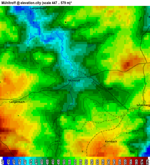
Below is the Elevation map of Mühltroff, which displays elevation range with different colors. Scale of the first map is from 447 to 579 m (1467 to 1900 ft) with average elevation of 507.8 meters (=1666 ft) [note 1]
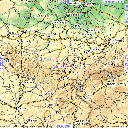
These maps also provides idea of topography and contour of this city, they are displayed at different zoom levels. More info about maps, scale and edge coordinates you can find below images.
| \ | Map #1 | Topo.Map |
| Scale [m] | 447..579 m | × |
| Scale [ft] | 1467..1900 ft | × |
| Average | 507.8 m = 1666 ft | × |
| Width | 6.21 km = 3.9 mi | 198.8 km = 123.5 mi |
| Height | 6.21 km = 3.9 mi | 198.7 km = 123.5 mi |
| ↑Max Latitude | 50.567111° | 51.42448° |
| Latitude at center | 50.53919° | 50.53919° |
| ↓Min Latitude | 50.511252° | 49.63696° |
| ← Min Longitude | 11.884335° | 10.52203° |
| Longitude center | 11.92828° | 11.92828° |
| →Max Longitude | 11.972225° | 13.33453° |
Nearby cities:
Cities around Mühltroff sort by population:
• Plauen elevation 361 m
15.5 km,  107°
107°
• Zeulenroda 411 m
13.2 km,  17°
17°
• Schleiz 437 m
9.4 km,  297°
297°
• Elsterberg 290 m
18.6 km,  65°
65°
• Tanna 551 m
7.1 km,  225°
225°
• Triebes 354 m
17.5 km, 21°
• Pausa 444 m
6.8 km,  45°
45°
• Weischlitz 387 m
13.9 km,  135°
135°
• Auma 395 m
18 km,  353°
353°
• Syrau 463 m
10.7 km,  87°
87°
• Mehltheuer 513 m
7.7 km,  84°
84°
• Töpen 525 m
17 km,  193°
193°
Multilingual:
 En español:
Mühltroff elevación 480 m.
 En France:
Mühltroff élévation 480 m.
 Auf Deutsch:
Mühltroff höhe über dem Meeresspiegel ist 480 m.

Sources and notes:
- [note 1] Map square and city borders are not equal. Map elevation data is calculated only from area inside that square.
- [src 1] Elevation data from geonames database provided with same terms of usage.
- [src 2] The elevation map of Mühltroff is generated using elevation data from NASA's 3 arcsec (90m) resolution SRTM data.
- [src 3] Base (background) map © OpenStreetMap contributors tiles are generated by Geofabrik and OpenTopoMap.
Copyright & License:
This Mühltroff Elevation Map is licensed under CC BY-SA. You may reuse any part from this page, if you give a proper credit by linking to this URL:
 More info on terms of use page.