Plauen elevation
Plauen (Saxony), Germany elevation is 361 meters and Plauen elevation in feet is 1184 ft above sea level [src 1]. Plauen is a seat of a third-order administrative division (feature code) with elevation that is 103 meters (338 ft) bigger than average city elevation in Germany.
Below is the Elevation map of Plauen, which displays elevation range with different colors. Scale of the first map is from 322 to 503 m (1056 to 1650 ft) with average elevation of 392.7 meters (=1288 ft) [note 1]
These maps also provides idea of topography and contour of this city, they are displayed at different zoom levels. More info about maps, scale and edge coordinates you can find below images.

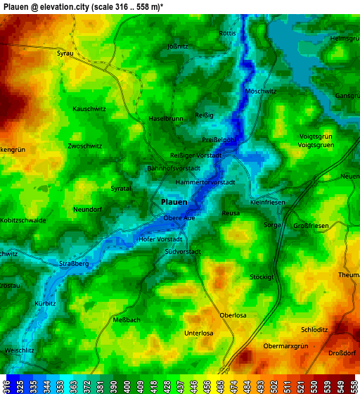
| \ | Map #1 | Map #2 | Topo.Map |
| Scale [m] | 322..503 m | 316..558 m | × |
| Scale [ft] | 1056..1650 ft | 1037..1831 ft | × |
| Average | 392.7 m = 1288 ft | 420.7 m = 1380 ft | × |
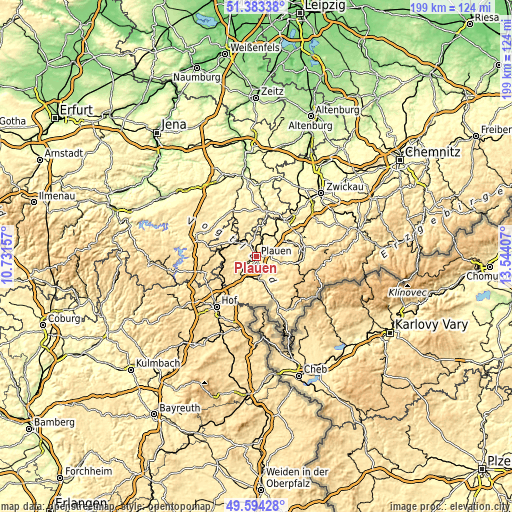
| Width | 6.22 km = 3.9 mi | 12.43 km = 7.7 mi | 198.9 km = 123.6 mi |
| Height | 6.22 km = 3.9 mi | 12.43 km = 7.7 mi | 198.9 km = 123.6 mi |
| ↑Max Latitude | 50.525246° | 50.553175° | 51.38338° |
| Latitude at center | 50.4973° | 50.4973° | 50.4973° |
| ↓Min Latitude | 50.469337° | 50.441358° | 49.59428° |
| ← Min Longitude | 12.093875° | 12.049929° | 10.73157° |
| Longitude center | 12.13782° | 12.13782° | 12.13782° |
| →Max Longitude | 12.181765° | 12.225711° | 13.54407° |
Nearby cities:
Cities around Plauen sort by population:
• Oelsnitz elevation 397 m
9.5 km,  166°
166°
• Treuen 465 m
12.7 km,  66°
66°
• Elsterberg 290 m
12.5 km,  9°
9°
• Weischlitz 387 m
7.3 km,  223°
223°
• Neuensalz 426 m
5.6 km,  86°
86°
• Syrau 463 m
6.5 km,  320°
320°
• Mehltheuer 513 m
8.9 km,  306°
306°
• Limbach 407 m
12.4 km,  39°
39°
• Tirpersdorf 480 m
10.7 km,  131°
131°
• Bösenbrunn 430 m
11.5 km,  193°
193°
• Theuma 486 m
6.7 km,  116°
116°
• Bergen 464 m
10.1 km,  106°
106°
Multilingual:
 En español:
Plauen elevación 361 m.
 En France:
Plauen élévation 361 m.


Sources and notes:
- [note 1] Map square and city borders are not equal. Map elevation data is calculated only from area inside that square.
- [src 1] Elevation data from geonames database provided with same terms of usage.
- [src 2] The elevation map of Plauen is generated using elevation data from NASA's 3 arcsec (90m) resolution SRTM data.
- [src 3] Base (background) map © OpenStreetMap contributors tiles are generated by Geofabrik and OpenTopoMap.
Copyright & License:
This Plauen Elevation Map is licensed under CC BY-SA. You may reuse any part from this page, if you give a proper credit by linking to this URL:
 More info on terms of use page.