Syrau elevation
Syrau (Saxony), Germany elevation is 463 meters and Syrau elevation in feet is 1519 ft above sea level [src 1]. Syrau is a populated place (feature code) with elevation that is 205 meters (673 ft) bigger than average city elevation in Germany.
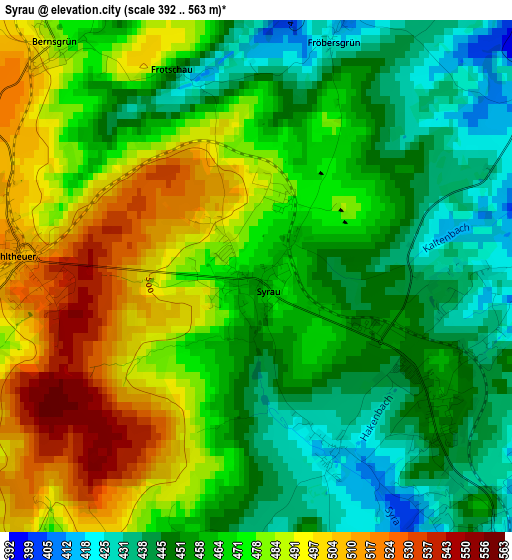
Below is the Elevation map of Syrau, which displays elevation range with different colors. Scale of the first map is from 392 to 563 m (1286 to 1847 ft) with average elevation of 468.4 meters (=1537 ft) [note 1]
These maps also provides idea of topography and contour of this city, they are displayed at different zoom levels. More info about maps, scale and edge coordinates you can find below images.
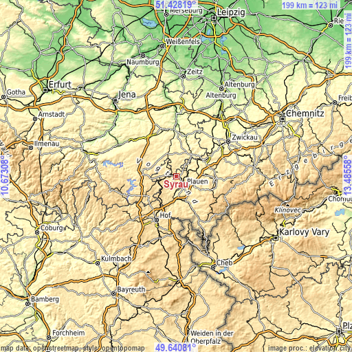
| \ | Map #1 | Topo.Map |
| Scale [m] | 392..563 m | × |
| Scale [ft] | 1286..1847 ft | × |
| Average | 468.4 m = 1537 ft | × |
| Width | 6.21 km = 3.9 mi | 198.7 km = 123.5 mi |
| Height | 6.21 km = 3.9 mi | 198.7 km = 123.5 mi |
| ↑Max Latitude | 50.570889° | 51.42819° |
| Latitude at center | 50.54297° | 50.54297° |
| ↓Min Latitude | 50.515035° | 49.64081° |
| ← Min Longitude | 12.035385° | 10.67308° |
| Longitude center | 12.07933° | 12.07933° |
| →Max Longitude | 12.123275° | 13.48558° |
Nearby cities:
Cities around Syrau sort by population:
• Plauen elevation 361 m
6.5 km,  140°
140°
• Zeulenroda 411 m
13.9 km,  331°
331°
• Elsterberg 290 m
9.6 km,  40°
40°
• Netzschkau 379 m
14.1 km,  55°
55°
• Pausa 444 m
7.2 km,  306°
306°
• Weischlitz 387 m
10.4 km,  184°
184°
• Neuensalz 426 m
10.8 km,  116°
116°
• Mühltroff 480 m
10.7 km,  267°
267°
• Mehltheuer 513 m
3 km, 274°
• Limbach 407 m
12.9 km,  69°
69°
• Theuma 486 m
12.9 km,  128°
128°
• Reuth 403 m
12.7 km,  49°
49°
Multilingual:
 En español:
Syrau elevación 463 m.
 En France:
Syrau élévation 463 m.


Sources and notes:
- [note 1] Map square and city borders are not equal. Map elevation data is calculated only from area inside that square.
- [src 1] Elevation data from geonames database provided with same terms of usage.
- [src 2] The elevation map of Syrau is generated using elevation data from NASA's 3 arcsec (90m) resolution SRTM data.
- [src 3] Base (background) map © OpenStreetMap contributors tiles are generated by Geofabrik and OpenTopoMap.
Copyright & License:
This Syrau Elevation Map is licensed under CC BY-SA. You may reuse any part from this page, if you give a proper credit by linking to this URL:
 More info on terms of use page.