Schleiz elevation
Schleiz (Thuringia), Germany elevation is 437 meters and Schleiz elevation in feet is 1434 ft above sea level [src 1]. Schleiz is a seat of a third-order administrative division (feature code) with elevation that is 179 meters (587 ft) bigger than average city elevation in Germany.
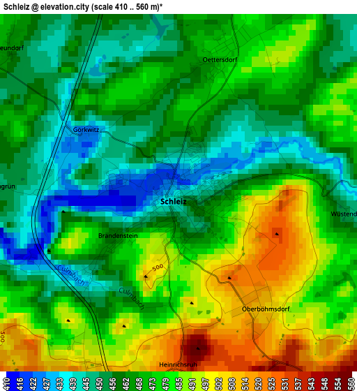
Below is the Elevation map of Schleiz, which displays elevation range with different colors. Scale of the first map is from 410 to 560 m (1345 to 1837 ft) with average elevation of 470.9 meters (=1545 ft) [note 1]
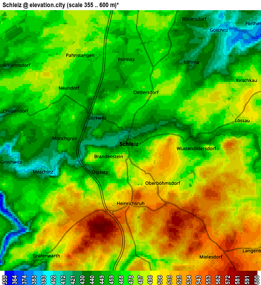
These maps also provides idea of topography and contour of this city, they are displayed at different zoom levels. More info about maps, scale and edge coordinates you can find below images.
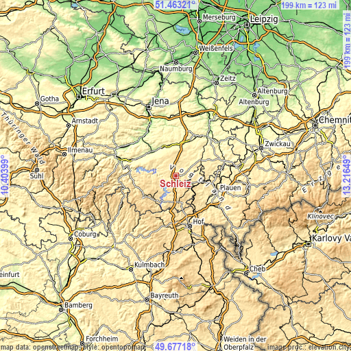
| \ | Map #1 | Map #2 | Topo.Map |
| Scale [m] | 410..560 m | 355..600 m | × |
| Scale [ft] | 1345..1837 ft | 1165..1969 ft | × |
| Average | 470.9 m = 1545 ft | 478.4 m = 1570 ft | × |
| Width | 6.21 km = 3.9 mi | 12.41 km = 7.7 mi | 198.6 km = 123.4 mi |
| Height | 6.21 km = 3.9 mi | 12.41 km = 7.7 mi | 198.6 km = 123.4 mi |
| ↑Max Latitude | 50.606558° | 50.634439° | 51.46321° |
| Latitude at center | 50.57866° | 50.57866° | 50.57866° |
| ↓Min Latitude | 50.550746° | 50.522815° | 49.67718° |
| ← Min Longitude | 11.766295° | 11.722349° | 10.40399° |
| Longitude center | 11.81024° | 11.81024° | 11.81024° |
| →Max Longitude | 11.854185° | 11.898131° | 13.21649° |
Nearby cities:
Cities around Schleiz sort by population:
• Zeulenroda elevation 411 m
14.8 km,  56°
56°
• Neustadt an der Orla 301 m
18.1 km,  345°
345°
• Bad Lobenstein 506 m
18.5 km,  220°
220°
• Tanna 551 m
9.9 km,  160°
160°
• Remptendorf 522 m
12.4 km,  245°
245°
• Triptis 365 m
18 km,  13°
13°
• Triebes 354 m
19 km,  51°
51°
• Pausa 444 m
13.2 km,  88°
88°
• Auma 395 m
14.9 km,  24°
24°
• Mühltroff 480 m
9.4 km,  117°
117°
• Mehltheuer 513 m
16.4 km,  103°
103°
• Oppurg 218 m
18.4 km,  322°
322°
Multilingual:
 En español:
Schleiz elevación 437 m.
 En France:
Schleiz élévation 437 m.


Sources and notes:
- [note 1] Map square and city borders are not equal. Map elevation data is calculated only from area inside that square.
- [src 1] Elevation data from geonames database provided with same terms of usage.
- [src 2] The elevation map of Schleiz is generated using elevation data from NASA's 3 arcsec (90m) resolution SRTM data.
- [src 3] Base (background) map © OpenStreetMap contributors tiles are generated by Geofabrik and OpenTopoMap.
Copyright & License:
This Schleiz Elevation Map is licensed under CC BY-SA. You may reuse any part from this page, if you give a proper credit by linking to this URL:
 More info on terms of use page.