Röbel elevation
Röbel (Mecklenburg-Vorpommern), Germany elevation is 67 meters and Röbel elevation in feet is 220 ft above sea level [src 1]. Röbel is a populated place (feature code) with elevation that is 191 meters (627 ft) smaller than average city elevation in Germany.
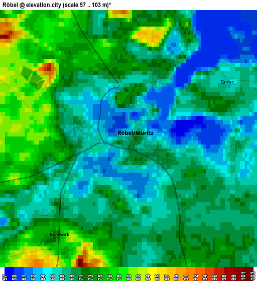
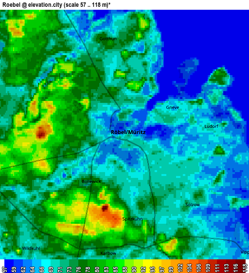
Below is the Elevation map of Röbel, which displays elevation range with different colors. Scale of the first map is from 57 to 103 m (187 to 338 ft) with average elevation of 70.5 meters (=231 ft) [note 1]
These maps also provides idea of topography and contour of this city, they are displayed at different zoom levels. More info about maps, scale and edge coordinates you can find below images.
| \ | Map #1 | Map #2 | Topo.Map |
| Scale [m] | 57..103 m | 57..118 m | × |
| Scale [ft] | 187..338 ft | 187..387 ft | × |
| Average | 70.5 m = 231 ft | 72.2 m = 237 ft | × |
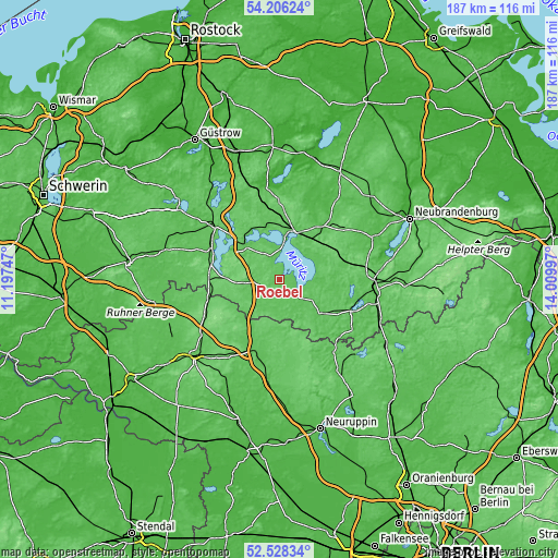
| Width | 5.83 km = 3.6 mi | 11.66 km = 7.2 mi | 186.6 km = 115.9 mi |
| Height | 5.83 km = 3.6 mi | 11.66 km = 7.2 mi | 186.5 km = 115.9 mi |
| ↑Max Latitude | 53.401758° | 53.42795° | 54.20624° |
| Latitude at center | 53.37555° | 53.37555° | 53.37555° |
| ↓Min Latitude | 53.349326° | 53.323085° | 52.52834° |
| ← Min Longitude | 12.559775° | 12.515829° | 11.19747° |
| Longitude center | 12.60372° | 12.60372° | 12.60372° |
| →Max Longitude | 12.647665° | 12.691611° | 14.00997° |
Nearby cities:
Cities around Röbel sort by population:
• Neustrelitz elevation 71 m
31.2 km,  92°
92°
• Waren 66 m
16.9 km,  17°
17°
• Wittstock 66 m
25.2 km,  198°
198°
• Malchow 77 m
16.3 km,  312°
312°
• Plau am See 74 m
24.4 km,  292°
292°
• Heiligengrabe 79 m
30.3 km,  211°
211°
• Wesenberg 59 m
26.5 km,  113°
113°
• Penzlin 51 m
34.9 km,  65°
65°
• Rechlin 67 m
9.2 km,  118°
118°
• Möllenhagen 89 m
27.1 km,  52°
52°
• Klink 73 m
11.4 km,  5°
5°
• Grabowhöfe 74 m
21.5 km,  358°
358°
Multilingual:
 En español:
Röbel elevación 67 m.
 En France:
Röbel élévation 67 m.


Sources and notes:
- [note 1] Map square and city borders are not equal. Map elevation data is calculated only from area inside that square.
- [src 1] Elevation data from geonames database provided with same terms of usage.
- [src 2] The elevation map of Röbel is generated using elevation data from NASA's 3 arcsec (90m) resolution SRTM data.
- [src 3] Base (background) map © OpenStreetMap contributors tiles are generated by Geofabrik and OpenTopoMap.
Copyright & License:
This Röbel Elevation Map is licensed under CC BY-SA. You may reuse any part from this page, if you give a proper credit by linking to this URL:
 More info on terms of use page.