Stadtlauringen elevation
Stadtlauringen (Bavaria, Regierungsbezirk Unterfranken), Germany elevation is 292 meters and Stadtlauringen elevation in feet is 958 ft above sea level [src 1]. Stadtlauringen is a populated place (feature code) with elevation that is 34 meters (112 ft) bigger than average city elevation in Germany.
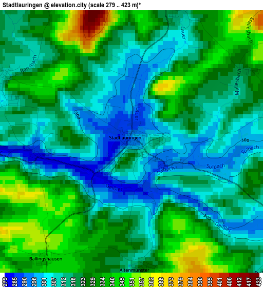
Below is the Elevation map of Stadtlauringen, which displays elevation range with different colors. Scale of the first map is from 279 to 423 m (915 to 1388 ft) with average elevation of 321.3 meters (=1054 ft) [note 1]
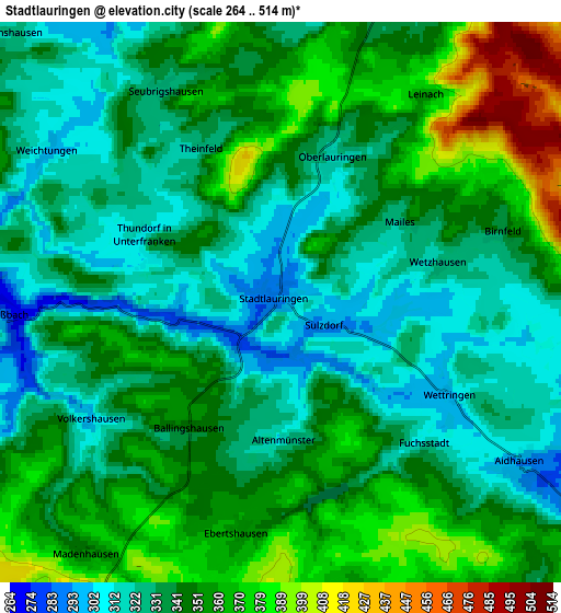
These maps also provides idea of topography and contour of this city, they are displayed at different zoom levels. More info about maps, scale and edge coordinates you can find below images.
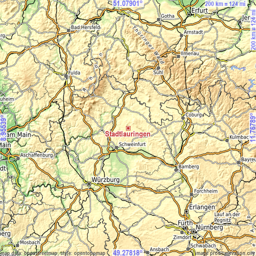
| \ | Map #1 | Map #2 | Topo.Map |
| Scale [m] | 279..423 m | 264..514 m | × |
| Scale [ft] | 915..1388 ft | 866..1686 ft | × |
| Average | 321.3 m = 1054 ft | 343.2 m = 1126 ft | × |
| Width | 6.26 km = 3.9 mi | 12.51 km = 7.8 mi | 200.2 km = 124.4 mi |
| Height | 6.26 km = 3.9 mi | 12.51 km = 7.8 mi | 200.2 km = 124.4 mi |
| ↑Max Latitude | 50.215209° | 50.243322° | 51.07901° |
| Latitude at center | 50.18708° | 50.18708° | 50.18708° |
| ↓Min Latitude | 50.158934° | 50.130772° | 49.27818° |
| ← Min Longitude | 10.317695° | 10.273749° | 8.95539° |
| Longitude center | 10.36164° | 10.36164° | 10.36164° |
| →Max Longitude | 10.405585° | 10.449531° | 11.76789° |
Nearby cities:
Cities around Stadtlauringen sort by population:
• Münnerstadt elevation 248 m
13.1 km,  300°
300°
• Bad Königshofen im Grabfeld 281 m
14.8 km,  31°
31°
• Hofheim in Unterfranken 266 m
12.8 km,  115°
115°
• Maßbach 284 m
6.2 km,  265°
265°
• Üchtelhausen 306 m
12.5 km,  212°
212°
• Aidhausen 305 m
6.6 km,  128°
128°
• Sulzfeld 300 m
8.7 km,  21°
21°
• Saal an der Saale 257 m
14.4 km,  358°
358°
• Rannungen 342 m
11.4 km,  257°
257°
• Thundorf in Unterfranken 311 m
3.4 km, 297°
• Großeibstadt 283 m
13.1 km, 15°
• Großbardorf 289 m
8.9 km,  2°
2°
Multilingual:
 En español:
Stadtlauringen elevación 292 m.
 En France:
Stadtlauringen élévation 292 m.
 Auf Deutsch:
Stadtlauringen höhe über dem Meeresspiegel ist 292 m.

Sources and notes:
- [note 1] Map square and city borders are not equal. Map elevation data is calculated only from area inside that square.
- [src 1] Elevation data from geonames database provided with same terms of usage.
- [src 2] The elevation map of Stadtlauringen is generated using elevation data from NASA's 3 arcsec (90m) resolution SRTM data.
- [src 3] Base (background) map © OpenStreetMap contributors tiles are generated by Geofabrik and OpenTopoMap.
Copyright & License:
This Stadtlauringen Elevation Map is licensed under CC BY-SA. You may reuse any part from this page, if you give a proper credit by linking to this URL:
 More info on terms of use page.