Bad Königshofen im Grabfeld elevation
Bad Königshofen im Grabfeld (Bavaria, Regierungsbezirk Unterfranken), Germany elevation is 281 meters and Bad Königshofen im Grabfeld elevation in feet is 922 ft above sea level [src 1]. Bad Königshofen im Grabfeld is a populated place (feature code) with elevation that is 23 meters (75 ft) bigger than average city elevation in Germany.
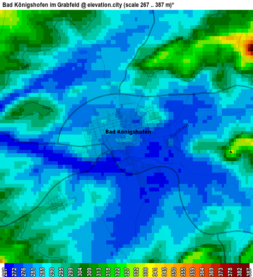
Below is the Elevation map of Bad Königshofen im Grabfeld, which displays elevation range with different colors. Scale of the first map is from 267 to 387 m (876 to 1270 ft) with average elevation of 289.2 meters (=949 ft) [note 1]
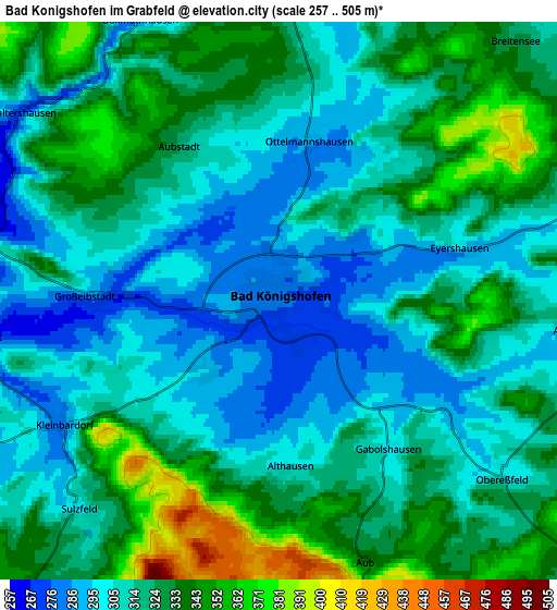
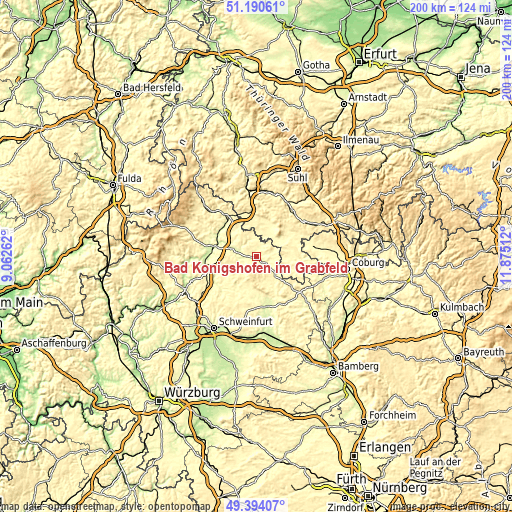
These maps also provides idea of topography and contour of this city, they are displayed at different zoom levels. More info about maps, scale and edge coordinates you can find below images.
| \ | Map #1 | Map #2 | Topo.Map |
| Scale [m] | 267..387 m | 257..505 m | × |
| Scale [ft] | 876..1270 ft | 843..1657 ft | × |
| Average | 289.2 m = 949 ft | 319.1 m = 1047 ft | × |
| Width | 6.24 km = 3.9 mi | 12.48 km = 7.8 mi | 199.8 km = 124.1 mi |
| Height | 6.24 km = 3.9 mi | 12.48 km = 7.8 mi | 199.7 km = 124.1 mi |
| ↑Max Latitude | 50.328882° | 50.356928° | 51.19061° |
| Latitude at center | 50.30082° | 50.30082° | 50.30082° |
| ↓Min Latitude | 50.272741° | 50.244646° | 49.39407° |
| ← Min Longitude | 10.424925° | 10.380979° | 9.06262° |
| Longitude center | 10.46887° | 10.46887° | 10.46887° |
| →Max Longitude | 10.512815° | 10.556761° | 11.87512° |
Nearby cities:
Cities around Bad Königshofen im Grabfeld sort by population:
• Gleichamberg elevation 328 m
12 km,  49°
49°
• Römhild 305 m
11.7 km,  25°
25°
• Sulzfeld 300 m
6.4 km,  224°
224°
• Hollstadt 243 m
13.2 km,  294°
294°
• Saal an der Saale 257 m
8.1 km,  282°
282°
• Wülfershausen 251 m
9.7 km, 290°
• Höchheim 312 m
7.4 km,  349°
349°
• Großeibstadt 283 m
4.2 km,  270°
270°
• Milz 299 m
9.8 km, 29°
• Trappstadt 311 m
7.5 km,  74°
74°
• Hendungen 307 m
13.3 km,  321°
321°
• Großbardorf 289 m
8.2 km,  242°
242°
Multilingual:
 En español:
Bad Königshofen im Grabfeld elevación 281 m.
 En France:
Bad Königshofen im Grabfeld élévation 281 m.
 Auf Deutsch:
Bad Königshofen im Grabfeld höhe über dem Meeresspiegel ist 281 m.
 На русском:
Бад-Кёнигсхофен-им-Грабфельд высота над уровнем моря 281 м
Sources and notes:
- [note 1] Map square and city borders are not equal. Map elevation data is calculated only from area inside that square.
- [src 1] Elevation data from geonames database provided with same terms of usage.
- [src 2] The elevation map of Bad Königshofen im Grabfeld is generated using elevation data from NASA's 3 arcsec (90m) resolution SRTM data.
- [src 3] Base (background) map © OpenStreetMap contributors tiles are generated by Geofabrik and OpenTopoMap.
Copyright & License:
This Bad Königshofen im Grabfeld Elevation Map is licensed under CC BY-SA. You may reuse any part from this page, if you give a proper credit by linking to this URL:
 More info on terms of use page.