Teisnach elevation
Teisnach (Bavaria, Lower Bavaria), Germany elevation is 465 meters and Teisnach elevation in feet is 1526 ft above sea level [src 1]. Teisnach is a populated place (feature code) with elevation that is 207 meters (679 ft) bigger than average city elevation in Germany.
Below is the Elevation map of Teisnach, which displays elevation range with different colors. Scale of the first map is from 414 to 798 m (1358 to 2618 ft) with average elevation of 543.3 meters (=1782 ft) [note 1]
These maps also provides idea of topography and contour of this city, they are displayed at different zoom levels. More info about maps, scale and edge coordinates you can find below images.
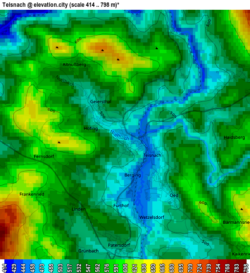
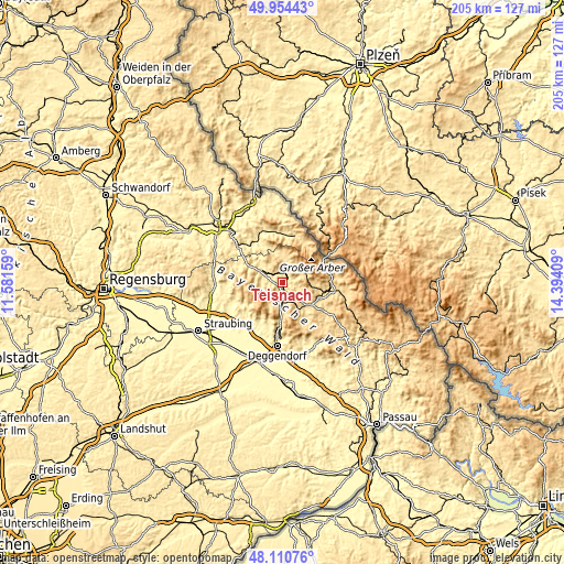
| \ | Map #1 | Topo.Map |
| Scale [m] | 414..798 m | × |
| Scale [ft] | 1358..2618 ft | × |
| Average | 543.3 m = 1782 ft | × |
| Width | 6.41 km = 4 mi | 205 km = 127.4 mi |
| Height | 6.41 km = 4 mi | 205 km = 127.4 mi |
| ↑Max Latitude | 49.069939° | 49.95443° |
| Latitude at center | 49.04114° | 49.04114° |
| ↓Min Latitude | 49.012325° | 48.11076° |
| ← Min Longitude | 12.943895° | 11.58159° |
| Longitude center | 12.98784° | 12.98784° |
| →Max Longitude | 13.031785° | 14.39409° |
Nearby cities:
Cities around Teisnach sort by population:
• Viechtach elevation 438 m
8.6 km,  300°
300°
• Bodenmais 690 m
8.7 km,  70°
70°
• Kollnburg 649 m
9.2 km,  273°
273°
• Drachselsried 532 m
7.6 km,  13°
13°
• Geiersthal 517 m
0.7 km,  318°
318°
• Ruhmannsfelden 530 m
6.4 km,  182°
182°
• Zachenberg 608 m
8.3 km,  173°
173°
• Arnbruck 571 m
9.9 km,  4°
4°
• Patersdorf 523 m
2.7 km,  186°
186°
• Sankt Englmar 840 m
12.5 km,  250°
250°
• Gotteszell 552 m
8.4 km, 190°
• Achslach 595 m
8.6 km,  206°
206°
Multilingual:
 En español:
Teisnach elevación 465 m.
 En France:
Teisnach élévation 465 m.
 Auf Deutsch:
Teisnach höhe über dem Meeresspiegel ist 465 m.

Sources and notes:
- [note 1] Map square and city borders are not equal. Map elevation data is calculated only from area inside that square.
- [src 1] Elevation data from geonames database provided with same terms of usage.
- [src 2] The elevation map of Teisnach is generated using elevation data from NASA's 3 arcsec (90m) resolution SRTM data.
- [src 3] Base (background) map © OpenStreetMap contributors tiles are generated by Geofabrik and OpenTopoMap.
Copyright & License:
This Teisnach Elevation Map is licensed under CC BY-SA. You may reuse any part from this page, if you give a proper credit by linking to this URL:
 More info on terms of use page.