Kollnburg elevation
Kollnburg (Bavaria, Lower Bavaria), Germany elevation is 649 meters and Kollnburg elevation in feet is 2129 ft above sea level [src 1]. Kollnburg is a seat of a fourth-order administrative division (feature code) with elevation that is 391 meters (1283 ft) bigger than average city elevation in Germany.
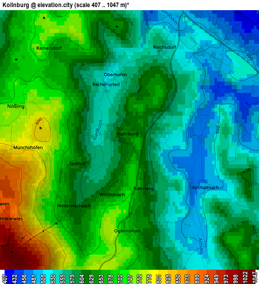
Below is the Elevation map of Kollnburg, which displays elevation range with different colors. Scale of the first map is from 407 to 1047 m (1335 to 3435 ft) with average elevation of 622.9 meters (=2044 ft) [note 1]
These maps also provides idea of topography and contour of this city, they are displayed at different zoom levels. More info about maps, scale and edge coordinates you can find below images.
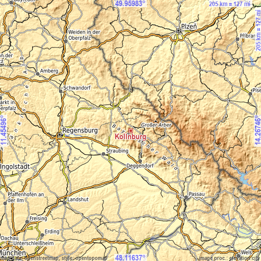
| \ | Map #1 | Topo.Map |
| Scale [m] | 407..1047 m | × |
| Scale [ft] | 1335..3435 ft | × |
| Average | 622.9 m = 2044 ft | × |
| Width | 6.41 km = 4 mi | 205 km = 127.4 mi |
| Height | 6.41 km = 4 mi | 205 km = 127.4 mi |
| ↑Max Latitude | 49.075435° | 49.95983° |
| Latitude at center | 49.04664° | 49.04664° |
| ↓Min Latitude | 49.017828° | 48.11637° |
| ← Min Longitude | 12.817265° | 11.45496° |
| Longitude center | 12.86121° | 12.86121° |
| →Max Longitude | 12.905155° | 14.26746° |
Nearby cities:
Cities around Kollnburg sort by population:
• Viechtach elevation 438 m
4.1 km,  25°
25°
• Teisnach 465 m
9.2 km,  93°
93°
• Prackenbach 498 m
6 km,  334°
334°
• Geiersthal 517 m
8.8 km, 90°
• Ruhmannsfelden 530 m
11.4 km,  128°
128°
• Rattenberg 541 m
9.3 km,  298°
298°
• Patersdorf 523 m
9.5 km,  110°
110°
• Konzell 587 m
11.3 km,  284°
284°
• Neukirchen 373 m
11.1 km,  224°
224°
• Sankt Englmar 840 m
5.5 km,  207°
207°
• Gotteszell 552 m
11.8 km,  139°
139°
• Achslach 595 m
9.9 km,  147°
147°
Multilingual:
 En español:
Kollnburg elevación 649 m.
 En France:
Kollnburg élévation 649 m.
 Auf Deutsch:
Kollnburg höhe über dem Meeresspiegel ist 649 m.

Sources and notes:
- [note 1] Map square and city borders are not equal. Map elevation data is calculated only from area inside that square.
- [src 1] Elevation data from geonames database provided with same terms of usage.
- [src 2] The elevation map of Kollnburg is generated using elevation data from NASA's 3 arcsec (90m) resolution SRTM data.
- [src 3] Base (background) map © OpenStreetMap contributors tiles are generated by Geofabrik and OpenTopoMap.
Copyright & License:
This Kollnburg Elevation Map is licensed under CC BY-SA. You may reuse any part from this page, if you give a proper credit by linking to this URL:
 More info on terms of use page.