Bodenmais elevation
Bodenmais (Bavaria, Lower Bavaria), Germany elevation is 690 meters and Bodenmais elevation in feet is 2264 ft above sea level [src 1]. Bodenmais is a populated place (feature code) with elevation that is 432 meters (1417 ft) bigger than average city elevation in Germany.
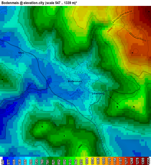
Below is the Elevation map of Bodenmais, which displays elevation range with different colors. Scale of the first map is from 547 to 1339 m (1795 to 4393 ft) with average elevation of 796.3 meters (=2613 ft) [note 1]
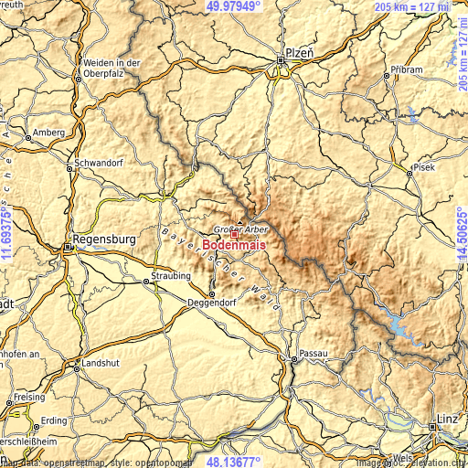
These maps also provides idea of topography and contour of this city, they are displayed at different zoom levels. More info about maps, scale and edge coordinates you can find below images.
| \ | Map #1 | Topo.Map |
| Scale [m] | 547..1339 m | × |
| Scale [ft] | 1795..4393 ft | × |
| Average | 796.3 m = 2613 ft | × |
| Width | 6.4 km = 4 mi | 204.9 km = 127.3 mi |
| Height | 6.4 km = 4 mi | 204.9 km = 127.3 mi |
| ↑Max Latitude | 49.095454° | 49.97949° |
| Latitude at center | 49.06667° | 49.06667° |
| ↓Min Latitude | 49.03787° | 48.13677° |
| ← Min Longitude | 13.056055° | 11.69375° |
| Longitude center | 13.1° | 13.1° |
| →Max Longitude | 13.143945° | 14.50625° |
Nearby cities:
Cities around Bodenmais sort by population:
• Regen elevation 544 m
10.7 km,  168°
168°
• Zwiesel 629 m
11.5 km,  118°
118°
• Teisnach 465 m
8.7 km,  250°
250°
• Drachselsried 532 m
7.9 km,  305°
305°
• Lindberg 670 m
11.7 km,  106°
106°
• Geiersthal 517 m
8.9 km, 254°
• Ruhmannsfelden 530 m
12.6 km,  222°
222°
• Zachenberg 608 m
13.3 km,  213°
213°
• Lohberg 662 m
12.2 km,  1°
1°
• Arnbruck 571 m
10.2 km, 313°
• Patersdorf 523 m
10.2 km,  236°
236°
• Bayerisch Eisenstein 789 m
9.2 km,  52°
52°
Multilingual:
 En español:
Bodenmais elevación 690 m.
 En France:
Bodenmais élévation 690 m.
 Auf Deutsch:
Bodenmais höhe über dem Meeresspiegel ist 690 m.

Sources and notes:
- [note 1] Map square and city borders are not equal. Map elevation data is calculated only from area inside that square.
- [src 1] Elevation data from geonames database provided with same terms of usage.
- [src 2] The elevation map of Bodenmais is generated using elevation data from NASA's 3 arcsec (90m) resolution SRTM data.
- [src 3] Base (background) map © OpenStreetMap contributors tiles are generated by Geofabrik and OpenTopoMap.
Copyright & License:
This Bodenmais Elevation Map is licensed under CC BY-SA. You may reuse any part from this page, if you give a proper credit by linking to this URL:
 More info on terms of use page.