Lohberg elevation
Lohberg (Bavaria, Upper Palatinate), Germany elevation is 662 meters and Lohberg elevation in feet is 2172 ft above sea level [src 1]. Lohberg is a seat of a fourth-order administrative division (feature code) with elevation that is 404 meters (1325 ft) bigger than average city elevation in Germany.
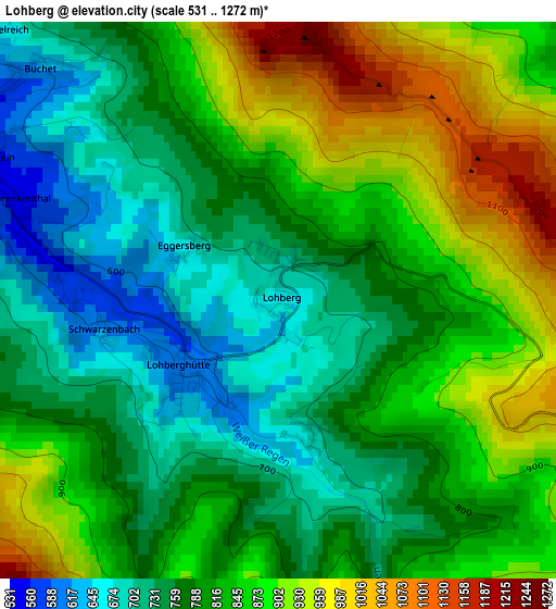
Below is the Elevation map of Lohberg, which displays elevation range with different colors. Scale of the first map is from 531 to 1272 m (1742 to 4173 ft) with average elevation of 816.9 meters (=2680 ft) [note 1]
These maps also provides idea of topography and contour of this city, they are displayed at different zoom levels. More info about maps, scale and edge coordinates you can find below images.
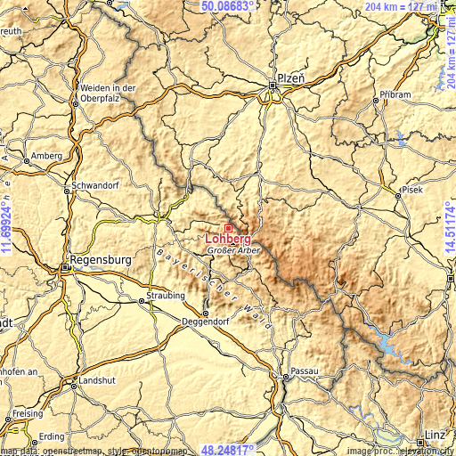
| \ | Map #1 | Topo.Map |
| Scale [m] | 531..1272 m | × |
| Scale [ft] | 1742..4173 ft | × |
| Average | 816.9 m = 2680 ft | × |
| Width | 6.39 km = 4 mi | 204.4 km = 127 mi |
| Height | 6.39 km = 4 mi | 204.4 km = 127 mi |
| ↑Max Latitude | 49.20476° | 50.08683° |
| Latitude at center | 49.17604° | 49.17604° |
| ↓Min Latitude | 49.147303° | 48.24817° |
| ← Min Longitude | 13.061545° | 11.69924° |
| Longitude center | 13.10549° | 13.10549° |
| →Max Longitude | 13.149435° | 14.51174° |
Nearby cities:
Cities around Lohberg sort by population:
• Neukirchen elevation 495 m
13.6 km,  313°
313°
• Bodenmais 690 m
12.2 km,  181°
181°
• Teisnach 465 m
17.3 km,  209°
209°
• Lam 574 m
4.6 km,  299°
299°
• Arrach 534 m
8.3 km,  281°
281°
• Drachselsried 532 m
10.2 km,  221°
221°
• Geiersthal 517 m
17.1 km, 211°
• Hohenwarth 532 m
12.8 km, 282°
• Arnbruck 571 m
9.3 km,  236°
236°
• Rimbach 587 m
17.4 km,  291°
291°
• Grafenwiesen 443 m
16.4 km, 279°
• Bayerisch Eisenstein 789 m
9.5 km,  133°
133°
Multilingual:
 En español:
Lohberg elevación 662 m.
 En France:
Lohberg élévation 662 m.


Sources and notes:
- [note 1] Map square and city borders are not equal. Map elevation data is calculated only from area inside that square.
- [src 1] Elevation data from geonames database provided with same terms of usage.
- [src 2] The elevation map of Lohberg is generated using elevation data from NASA's 3 arcsec (90m) resolution SRTM data.
- [src 3] Base (background) map © OpenStreetMap contributors tiles are generated by Geofabrik and OpenTopoMap.
Copyright & License:
This Lohberg Elevation Map is licensed under CC BY-SA. You may reuse any part from this page, if you give a proper credit by linking to this URL:
 More info on terms of use page.