Warendorf elevation
Warendorf (North Rhine-Westphalia, Regierungsbezirk Münster), Germany elevation is 58 meters and Warendorf elevation in feet is 190 ft above sea level [src 1]. Warendorf is a seat of a third-order administrative division (feature code) with elevation that is 200 meters (656 ft) smaller than average city elevation in Germany.
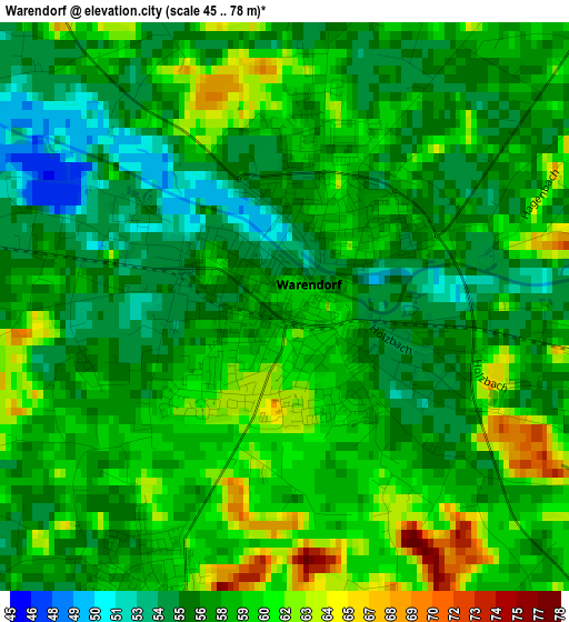
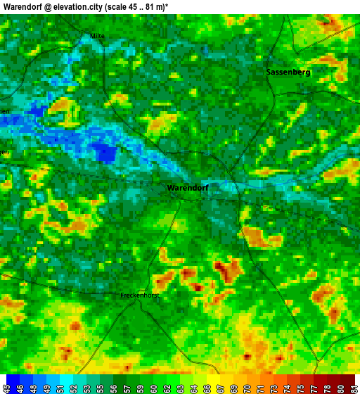
Below is the Elevation map of Warendorf, which displays elevation range with different colors. Scale of the first map is from 45 to 78 m (148 to 256 ft) with average elevation of 57.9 meters (=190 ft) [note 1]
These maps also provides idea of topography and contour of this city, they are displayed at different zoom levels. More info about maps, scale and edge coordinates you can find below images.

| \ | Map #1 | Map #2 | Topo.Map |
| Scale [m] | 45..78 m | 45..81 m | × |
| Scale [ft] | 148..256 ft | 148..266 ft | × |
| Average | 57.9 m = 190 ft | 59.3 m = 195 ft | × |
| Width | 6.02 km = 3.7 mi | 12.05 km = 7.5 mi | 192.7 km = 119.7 mi |
| Height | 6.02 km = 3.7 mi | 12.05 km = 7.5 mi | 192.7 km = 119.7 mi |
| ↑Max Latitude | 51.978167° | 52.005227° | 52.80946° |
| Latitude at center | 51.95109° | 51.95109° | 51.95109° |
| ↓Min Latitude | 51.923997° | 51.896887° | 51.07597° |
| ← Min Longitude | 7.943615° | 7.899669° | 6.58131° |
| Longitude center | 7.98756° | 7.98756° | 7.98756° |
| →Max Longitude | 8.031505° | 8.075451° | 9.39381° |
Nearby cities:
Cities around Warendorf sort by population:
• Oelde elevation 90 m
17.5 km,  141°
141°
• Harsewinkel 65 m
16.5 km,  85°
85°
• Versmold 70 m
15 km,  48°
48°
• Ennigerloh 104 m
12.9 km,  166°
166°
• Telgte 55 m
14.4 km,  282°
282°
• Sassenberg 61 m
5.8 km,  38°
38°
• Sendenhorst 69 m
16.2 km,  221°
221°
• Ostbevern 54 m
14 km,  314°
314°
• Everswinkel 72 m
10 km,  253°
253°
• Bad Laer 82 m
17.8 km,  21°
21°
• Glandorf 72 m
14.9 km,  3°
3°
• Beelen 60 m
8.8 km,  106°
106°
Multilingual:
 En español:
Warendorf elevación 58 m.
 En France:
Warendorf élévation 58 m.
 Auf Deutsch:
Warendorf höhe über dem Meeresspiegel ist 58 m.

Sources and notes:
- [note 1] Map square and city borders are not equal. Map elevation data is calculated only from area inside that square.
- [src 1] Elevation data from geonames database provided with same terms of usage.
- [src 2] The elevation map of Warendorf is generated using elevation data from NASA's 3 arcsec (90m) resolution SRTM data.
- [src 3] Base (background) map © OpenStreetMap contributors tiles are generated by Geofabrik and OpenTopoMap.
Copyright & License:
This Warendorf Elevation Map is licensed under CC BY-SA. You may reuse any part from this page, if you give a proper credit by linking to this URL:
 More info on terms of use page.