Glandorf elevation
Glandorf (Lower Saxony), Germany elevation is 72 meters and Glandorf elevation in feet is 236 ft above sea level [src 1]. Glandorf is a seat of a fourth-order administrative division (feature code) with elevation that is 186 meters (610 ft) smaller than average city elevation in Germany.
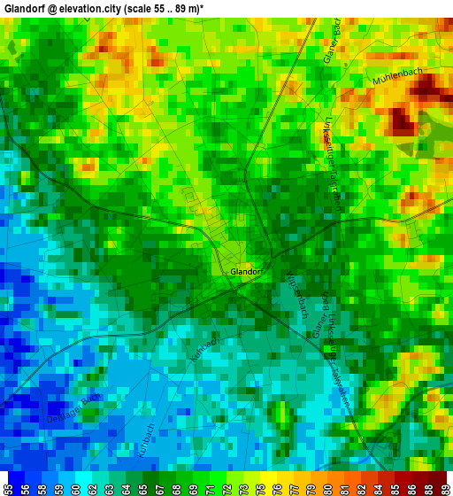
Below is the Elevation map of Glandorf, which displays elevation range with different colors. Scale of the first map is from 55 to 89 m (180 to 292 ft) with average elevation of 67.8 meters (=222 ft) [note 1]
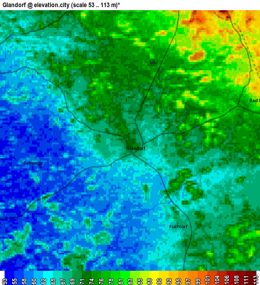
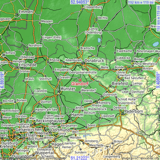
These maps also provides idea of topography and contour of this city, they are displayed at different zoom levels. More info about maps, scale and edge coordinates you can find below images.
| \ | Map #1 | Map #2 | Topo.Map |
| Scale [m] | 55..89 m | 53..113 m | × |
| Scale [ft] | 180..292 ft | 174..371 ft | × |
| Average | 67.8 m = 222 ft | 68.7 m = 225 ft | × |
| Width | 6.01 km = 3.7 mi | 12.01 km = 7.5 mi | 192.2 km = 119.4 mi |
| Height | 6.01 km = 3.7 mi | 12.01 km = 7.5 mi | 192.2 km = 119.4 mi |
| ↑Max Latitude | 52.111736° | 52.138716° | 52.94053° |
| Latitude at center | 52.08474° | 52.08474° | 52.08474° |
| ↓Min Latitude | 52.057728° | 52.030699° | 51.21222° |
| ← Min Longitude | 7.955495° | 7.911549° | 6.59319° |
| Longitude center | 7.99944° | 7.99944° | 7.99944° |
| →Max Longitude | 8.043385° | 8.087331° | 9.40569° |
Nearby cities:
Cities around Glandorf sort by population:
• Georgsmarienhütte elevation 117 m
13.5 km,  13°
13°
• Lengerich 81 m
14.8 km,  320°
320°
• Versmold 70 m
11.6 km,  115°
115°
• Sassenberg 61 m
10.7 km,  164°
164°
• Hagen 109 m
12.5 km,  354°
354°
• Bad Iburg 119 m
8.3 km,  20°
20°
• Ostbevern 54 m
11.8 km,  245°
245°
• Hilter 124 m
11.6 km,  60°
60°
• Dissen 107 m
14.1 km,  75°
75°
• Bad Laer 82 m
6 km,  73°
73°
• Lienen 91 m
7.3 km, 351°
• Bad Rothenfelde 100 m
12 km, 72°
Multilingual:
 En español:
Glandorf elevación 72 m.
 En France:
Glandorf élévation 72 m.


Sources and notes:
- [note 1] Map square and city borders are not equal. Map elevation data is calculated only from area inside that square.
- [src 1] Elevation data from geonames database provided with same terms of usage.
- [src 2] The elevation map of Glandorf is generated using elevation data from NASA's 3 arcsec (90m) resolution SRTM data.
- [src 3] Base (background) map © OpenStreetMap contributors tiles are generated by Geofabrik and OpenTopoMap.
Copyright & License:
This Glandorf Elevation Map is licensed under CC BY-SA. You may reuse any part from this page, if you give a proper credit by linking to this URL:
 More info on terms of use page.