Wegscheid elevation
Wegscheid (Bavaria, Lower Bavaria), Germany elevation is 716 meters and Wegscheid elevation in feet is 2349 ft above sea level [src 1]. Wegscheid is a populated place (feature code) with elevation that is 458 meters (1503 ft) bigger than average city elevation in Germany.
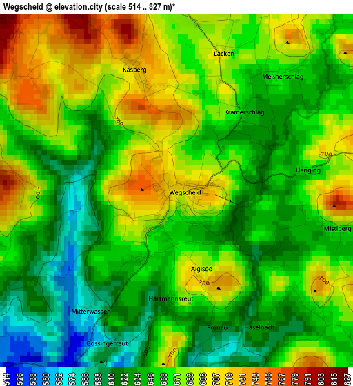
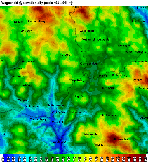
Below is the Elevation map of Wegscheid, which displays elevation range with different colors. Scale of the first map is from 514 to 827 m (1686 to 2713 ft) with average elevation of 661.8 meters (=2171 ft) [note 1]
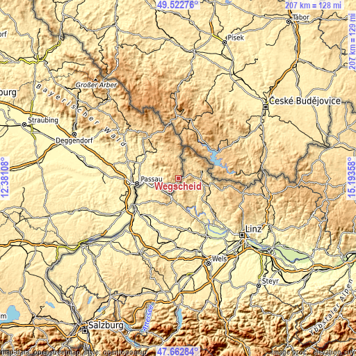
These maps also provides idea of topography and contour of this city, they are displayed at different zoom levels. More info about maps, scale and edge coordinates you can find below images.
| \ | Map #1 | Map #2 | Topo.Map |
| Scale [m] | 514..827 m | 493..941 m | × |
| Scale [ft] | 1686..2713 ft | 1617..3087 ft | × |
| Average | 661.8 m = 2171 ft | 685.8 m = 2250 ft | × |
| Width | 6.46 km = 4 mi | 12.93 km = 8 mi | 206.8 km = 128.5 mi |
| Height | 6.46 km = 4 mi | 12.93 km = 8 mi | 206.8 km = 128.5 mi |
| ↑Max Latitude | 48.630412° | 48.659448° | 49.52276° |
| Latitude at center | 48.60136° | 48.60136° | 48.60136° |
| ↓Min Latitude | 48.572291° | 48.543205° | 47.66284° |
| ← Min Longitude | 13.743385° | 13.699439° | 12.38108° |
| Longitude center | 13.78733° | 13.78733° | 13.78733° |
| →Max Longitude | 13.831275° | 13.875221° | 15.19358° |
Nearby cities:
Cities around Wegscheid sort by population:
• Hauzenberg elevation 526 m
13 km,  294°
294°
• Waldkirchen 547 m
20 km,  316°
316°
• Salzweg 454 m
22.4 km,  274°
274°
• Untergriesbach 555 m
9.3 km,  251°
251°
• Neureichenau 668 m
16.6 km,  349°
349°
• Thyrnau 432 m
18.8 km,  275°
275°
• Büchlberg 472 m
21.1 km, 291°
• Obernzell 295 m
12.2 km,  244°
244°
• Jandelsbrunn 630 m
16 km,  336°
336°
• Breitenberg 690 m
11.5 km,  2°
2°
• Witzmannsberg 430 m
21.7 km, 276°
• Sonnen 802 m
10.5 km,  330°
330°
Multilingual:
 En español:
Wegscheid elevación 716 m.
 En France:
Wegscheid élévation 716 m.
 Auf Deutsch:
Wegscheid höhe über dem Meeresspiegel ist 716 m.

Sources and notes:
- [note 1] Map square and city borders are not equal. Map elevation data is calculated only from area inside that square.
- [src 1] Elevation data from geonames database provided with same terms of usage.
- [src 2] The elevation map of Wegscheid is generated using elevation data from NASA's 3 arcsec (90m) resolution SRTM data.
- [src 3] Base (background) map © OpenStreetMap contributors tiles are generated by Geofabrik and OpenTopoMap.
Copyright & License:
This Wegscheid Elevation Map is licensed under CC BY-SA. You may reuse any part from this page, if you give a proper credit by linking to this URL:
 More info on terms of use page.