Obernzell elevation
Obernzell (Bavaria, Lower Bavaria), Germany elevation is 295 meters and Obernzell elevation in feet is 968 ft above sea level [src 1]. Obernzell is a populated place (feature code) with elevation that is 37 meters (121 ft) bigger than average city elevation in Germany.
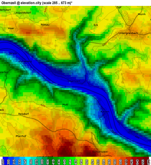
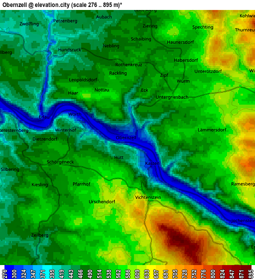
Below is the Elevation map of Obernzell, which displays elevation range with different colors. Scale of the first map is from 285 to 673 m (935 to 2208 ft) with average elevation of 466.4 meters (=1530 ft) [note 1]
These maps also provides idea of topography and contour of this city, they are displayed at different zoom levels. More info about maps, scale and edge coordinates you can find below images.
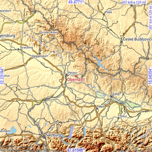
| \ | Map #1 | Map #2 | Topo.Map |
| Scale [m] | 285..673 m | 276..895 m | × |
| Scale [ft] | 935..2208 ft | 906..2936 ft | × |
| Average | 466.4 m = 1530 ft | 512.7 m = 1682 ft | × |
| Width | 6.47 km = 4 mi | 12.94 km = 8 mi | 207 km = 128.6 mi |
| Height | 6.47 km = 4 mi | 12.94 km = 8 mi | 207 km = 128.6 mi |
| ↑Max Latitude | 48.583929° | 48.612992° | 49.4771° |
| Latitude at center | 48.55485° | 48.55485° | 48.55485° |
| ↓Min Latitude | 48.525754° | 48.496642° | 47.61548° |
| ← Min Longitude | 13.593345° | 13.549399° | 12.23104° |
| Longitude center | 13.63729° | 13.63729° | 13.63729° |
| →Max Longitude | 13.681235° | 13.725181° | 15.04354° |
Nearby cities:
Cities around Obernzell sort by population:
• Passau elevation 366 m
15.2 km,  274°
274°
• Hauzenberg 526 m
10.6 km,  355°
355°
• Salzweg 454 m
13.2 km,  301°
301°
• Untergriesbach 555 m
3.1 km,  45°
45°
• Hutthurm 460 m
17.9 km,  317°
317°
• Wegscheid 716 m
12.2 km,  64°
64°
• Neuburg 432 m
15 km,  249°
249°
• Thyrnau 432 m
10.3 km,  311°
311°
• Büchlberg 472 m
15.5 km,  326°
326°
• Neuhaus am Inn 321 m
19.1 km,  236°
236°
• Witzmannsberg 430 m
12.9 km, 305°
• Sonnen 802 m
15.4 km,  22°
22°
Multilingual:
 En español:
Obernzell elevación 295 m.
 En France:
Obernzell élévation 295 m.
 Auf Deutsch:
Obernzell höhe über dem Meeresspiegel ist 295 m.

Sources and notes:
- [note 1] Map square and city borders are not equal. Map elevation data is calculated only from area inside that square.
- [src 1] Elevation data from geonames database provided with same terms of usage.
- [src 2] The elevation map of Obernzell is generated using elevation data from NASA's 3 arcsec (90m) resolution SRTM data.
- [src 3] Base (background) map © OpenStreetMap contributors tiles are generated by Geofabrik and OpenTopoMap.
Copyright & License:
This Obernzell Elevation Map is licensed under CC BY-SA. You may reuse any part from this page, if you give a proper credit by linking to this URL:
 More info on terms of use page.