Weikersheim elevation
Weikersheim (Baden-Württemberg, Regierungsbezirk Stuttgart), Germany elevation is 237 meters and Weikersheim elevation in feet is 778 ft above sea level [src 1]. Weikersheim is a populated place (feature code) with elevation that is 21 meters (69 ft) smaller than average city elevation in Germany.
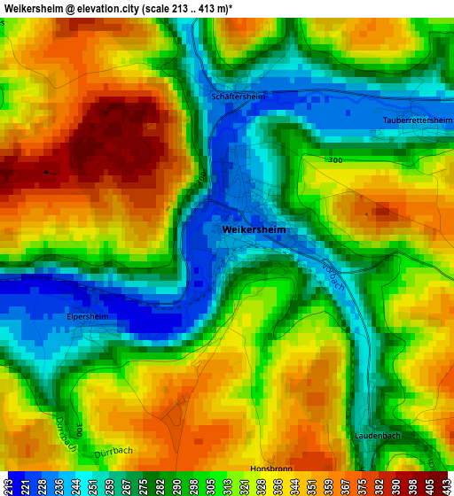
Below is the Elevation map of Weikersheim, which displays elevation range with different colors. Scale of the first map is from 213 to 413 m (699 to 1355 ft) with average elevation of 309.1 meters (=1014 ft) [note 1]
These maps also provides idea of topography and contour of this city, they are displayed at different zoom levels. More info about maps, scale and edge coordinates you can find below images.
| \ | Map #1 | Map #2 | Topo.Map |
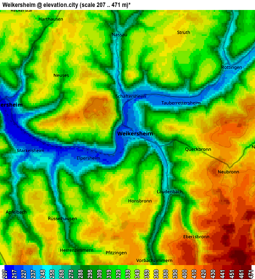
| Scale [m] | 213..413 m | 207..471 m | × |
| Scale [ft] | 699..1355 ft | 679..1545 ft | × |
| Average | 309.1 m = 1014 ft | 336 m = 1102 ft | × |
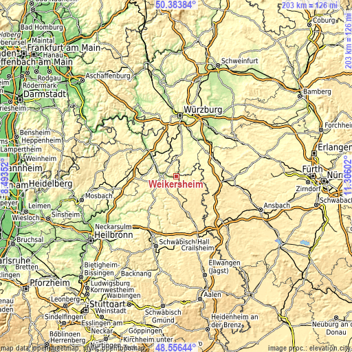
| Width | 6.35 km = 3.9 mi | 12.7 km = 7.9 mi | 203.2 km = 126.3 mi |
| Height | 6.35 km = 3.9 mi | 12.7 km = 7.9 mi | 203.2 km = 126.3 mi |
| ↑Max Latitude | 49.507204° | 49.535732° | 50.38384° |
| Latitude at center | 49.47866° | 49.47866° | 49.47866° |
| ↓Min Latitude | 49.450099° | 49.421521° | 48.55644° |
| ← Min Longitude | 9.855825° | 9.811879° | 8.49352° |
| Longitude center | 9.89977° | 9.89977° | 9.89977° |
| →Max Longitude | 9.943715° | 9.987661° | 11.30602° |
Nearby cities:
Cities around Weikersheim sort by population:
• Bad Mergentheim elevation 211 m
9.2 km,  279°
279°
• Lauda-Königshofen 195 m
16.9 km,  304°
304°
• Schrozberg 461 m
15.9 km,  158°
158°
• Igersheim 220 m
6.2 km,  286°
286°
• Niederstetten 311 m
8.9 km,  170°
170°
• Creglingen 272 m
9.6 km,  96°
96°
• Mulfingen 274 m
17 km,  204°
204°
• Dörzbach 244 m
17.5 km,  232°
232°
• Assamstadt 331 m
16.4 km,  249°
249°
• Röttingen 242 m
6.2 km,  56°
56°
• Aub 298 m
14.5 km, 55°
• Bütthard 285 m
13.5 km,  353°
353°
Multilingual:
 En español:
Weikersheim elevación 237 m.
 En France:
Weikersheim élévation 237 m.
 Auf Deutsch:
Weikersheim höhe über dem Meeresspiegel ist 237 m.

Sources and notes:
- [note 1] Map square and city borders are not equal. Map elevation data is calculated only from area inside that square.
- [src 1] Elevation data from geonames database provided with same terms of usage.
- [src 2] The elevation map of Weikersheim is generated using elevation data from NASA's 3 arcsec (90m) resolution SRTM data.
- [src 3] Base (background) map © OpenStreetMap contributors tiles are generated by Geofabrik and OpenTopoMap.
Copyright & License:
This Weikersheim Elevation Map is licensed under CC BY-SA. You may reuse any part from this page, if you give a proper credit by linking to this URL:
 More info on terms of use page.