Aub elevation
Aub (Bavaria, Regierungsbezirk Unterfranken), Germany elevation is 298 meters and Aub elevation in feet is 978 ft above sea level [src 1]. Aub is a populated place (feature code) with elevation that is 40 meters (131 ft) bigger than average city elevation in Germany.
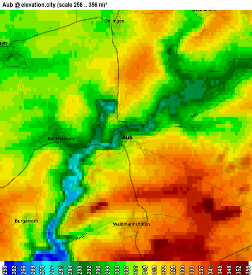
Below is the Elevation map of Aub, which displays elevation range with different colors. Scale of the first map is from 258 to 356 m (846 to 1168 ft) with average elevation of 314.8 meters (=1033 ft) [note 1]
These maps also provides idea of topography and contour of this city, they are displayed at different zoom levels. More info about maps, scale and edge coordinates you can find below images.
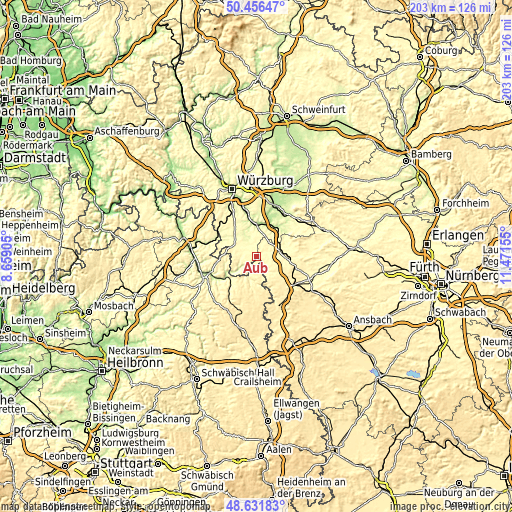
| \ | Map #1 | Topo.Map |
| Scale [m] | 258..356 m | × |
| Scale [ft] | 846..1168 ft | × |
| Average | 314.8 m = 1033 ft | × |
| Width | 6.34 km = 3.9 mi | 202.9 km = 126.1 mi |
| Height | 6.34 km = 3.9 mi | 202.9 km = 126.1 mi |
| ↑Max Latitude | 49.581171° | 50.45647° |
| Latitude at center | 49.55267° | 49.55267° |
| ↓Min Latitude | 49.524152° | 48.63183° |
| ← Min Longitude | 10.021355° | 8.65905° |
| Longitude center | 10.0653° | 10.0653° |
| →Max Longitude | 10.109245° | 11.47155° |
Nearby cities:
Cities around Aub sort by population:
• Ochsenfurt elevation 190 m
12.4 km,  358°
358°
• Uffenheim 327 m
12.1 km,  94°
94°
• Creglingen 272 m
9.6 km,  194°
194°
• Giebelstadt 300 m
14.2 km,  322°
322°
• Marktbreit 191 m
13.9 km,  25°
25°
• Gaukönigshofen 268 m
10.1 km,  332°
332°
• Obernbreit 199 m
13.8 km, 31°
• Röttingen 242 m
8.3 km,  234°
234°
• Bütthard 285 m
14.3 km,  291°
291°
• Frickenhausen 185 m
13.3 km,  8°
8°
• Ippesheim 280 m
12.8 km,  64°
64°
• Martinsheim 283 m
9.9 km,  37°
37°
Multilingual:
 En español:
Aub elevación 298 m.
 En France:
Aub élévation 298 m.


Sources and notes:
- [note 1] Map square and city borders are not equal. Map elevation data is calculated only from area inside that square.
- [src 1] Elevation data from geonames database provided with same terms of usage.
- [src 2] The elevation map of Aub is generated using elevation data from NASA's 3 arcsec (90m) resolution SRTM data.
- [src 3] Base (background) map © OpenStreetMap contributors tiles are generated by Geofabrik and OpenTopoMap.
Copyright & License:
This Aub Elevation Map is licensed under CC BY-SA. You may reuse any part from this page, if you give a proper credit by linking to this URL:
 More info on terms of use page.