Wonfurt elevation
Wonfurt (Bavaria, Regierungsbezirk Unterfranken), Germany elevation is 219 meters and Wonfurt elevation in feet is 719 ft above sea level [src 1]. Wonfurt is a seat of a fourth-order administrative division (feature code) with elevation that is 39 meters (128 ft) smaller than average city elevation in Germany.
Below is the Elevation map of Wonfurt, which displays elevation range with different colors. Scale of the first map is from 211 to 376 m (692 to 1234 ft) with average elevation of 252.7 meters (=829 ft) [note 1]
These maps also provides idea of topography and contour of this city, they are displayed at different zoom levels. More info about maps, scale and edge coordinates you can find below images.
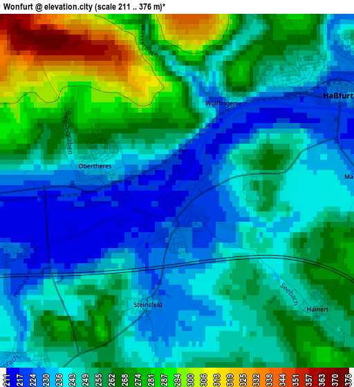
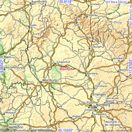
| \ | Map #1 | Topo.Map |
| Scale [m] | 211..376 m | × |
| Scale [ft] | 692..1234 ft | × |
| Average | 252.7 m = 829 ft | × |
| Width | 6.28 km = 3.9 mi | 200.9 km = 124.8 mi |
| Height | 6.28 km = 3.9 mi | 200.9 km = 124.8 mi |
| ↑Max Latitude | 50.044899° | 50.9118° |
| Latitude at center | 50.01667° | 50.01667° |
| ↓Min Latitude | 49.988424° | 49.10455° |
| ← Min Longitude | 10.422725° | 9.06042° |
| Longitude center | 10.46667° | 10.46667° |
| →Max Longitude | 10.510615° | 11.87292° |
Nearby cities:
Cities around Wonfurt sort by population:
• Haßfurt elevation 233 m
4.1 km,  59°
59°
• Schonungen 262 m
11.9 km,  288°
288°
• Knetzgau 247 m
7 km,  121°
121°
• Gochsheim 236 m
13.1 km,  270°
270°
• Zeil 235 m
9.2 km,  94°
94°
• Hofheim in Unterfranken 266 m
13.9 km,  16°
16°
• Grettstadt 237 m
11.3 km,  250°
250°
• Sand 236 m
9.2 km,  111°
111°
• Sulzheim 227 m
12.1 km,  232°
232°
• Donnersdorf 252 m
6.6 km,  212°
212°
• Dingolshausen 268 m
13.4 km,  204°
204°
• Michelau 292 m
12.6 km,  191°
191°
Multilingual:
 En español:
Wonfurt elevación 219 m.
 En France:
Wonfurt élévation 219 m.


Sources and notes:
- [note 1] Map square and city borders are not equal. Map elevation data is calculated only from area inside that square.
- [src 1] Elevation data from geonames database provided with same terms of usage.
- [src 2] The elevation map of Wonfurt is generated using elevation data from NASA's 3 arcsec (90m) resolution SRTM data.
- [src 3] Base (background) map © OpenStreetMap contributors tiles are generated by Geofabrik and OpenTopoMap.
Copyright & License:
This Wonfurt Elevation Map is licensed under CC BY-SA. You may reuse any part from this page, if you give a proper credit by linking to this URL:
 More info on terms of use page.