Sulzheim elevation
Sulzheim (Bavaria, Regierungsbezirk Unterfranken), Germany elevation is 227 meters and Sulzheim elevation in feet is 745 ft above sea level [src 1]. Sulzheim is a seat of a fourth-order administrative division (feature code) with elevation that is 31 meters (102 ft) smaller than average city elevation in Germany.
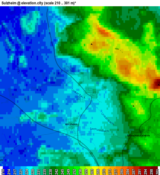
Below is the Elevation map of Sulzheim, which displays elevation range with different colors. Scale of the first map is from 210 to 301 m (689 to 988 ft) with average elevation of 232.7 meters (=763 ft) [note 1]
These maps also provides idea of topography and contour of this city, they are displayed at different zoom levels. More info about maps, scale and edge coordinates you can find below images.
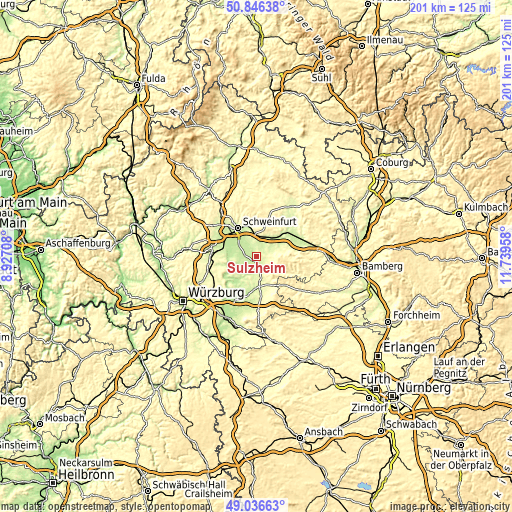
| \ | Map #1 | Topo.Map |
| Scale [m] | 210..301 m | × |
| Scale [ft] | 689..988 ft | × |
| Average | 232.7 m = 763 ft | × |
| Width | 6.29 km = 3.9 mi | 201.2 km = 125 mi |
| Height | 6.29 km = 3.9 mi | 201.2 km = 125 mi |
| ↑Max Latitude | 49.978269° | 50.84638° |
| Latitude at center | 49.95° | 49.95° |
| ↓Min Latitude | 49.921715° | 49.03663° |
| ← Min Longitude | 10.289385° | 8.92708° |
| Longitude center | 10.33333° | 10.33333° |
| →Max Longitude | 10.377275° | 11.73958° |
Nearby cities:
Cities around Sulzheim sort by population:
• Gerolzhofen elevation 241 m
5.6 km,  169°
169°
• Gochsheim 236 m
8.2 km,  334°
334°
• Kolitzheim 227 m
8.1 km,  242°
242°
• Röthlein 205 m
9.1 km,  293°
293°
• Grettstadt 237 m
3.9 km,  342°
342°
• Sennfeld 216 m
11.2 km, 332°
• Schwebheim 215 m
7.6 km,  306°
306°
• Grafenrheinfeld 208 m
11 km,  300°
300°
• Donnersdorf 252 m
6.2 km,  72°
72°
• Dingolshausen 268 m
6.3 km,  139°
139°
• Michelau 292 m
8.5 km,  125°
125°
• Frankenwinheim 230 m
7.1 km,  191°
191°
Multilingual:
 En español:
Sulzheim elevación 227 m.
 En France:
Sulzheim élévation 227 m.
 Auf Deutsch:
Sulzheim höhe über dem Meeresspiegel ist 227 m.

Sources and notes:
- [note 1] Map square and city borders are not equal. Map elevation data is calculated only from area inside that square.
- [src 1] Elevation data from geonames database provided with same terms of usage.
- [src 2] The elevation map of Sulzheim is generated using elevation data from NASA's 3 arcsec (90m) resolution SRTM data.
- [src 3] Base (background) map © OpenStreetMap contributors tiles are generated by Geofabrik and OpenTopoMap.
Copyright & License:
This Sulzheim Elevation Map is licensed under CC BY-SA. You may reuse any part from this page, if you give a proper credit by linking to this URL:
 More info on terms of use page.