Zeil elevation
Zeil (Bavaria, Regierungsbezirk Unterfranken), Germany elevation is 235 meters and Zeil elevation in feet is 771 ft above sea level [src 1]. Zeil is a populated place (feature code) with elevation that is 23 meters (75 ft) smaller than average city elevation in Germany.
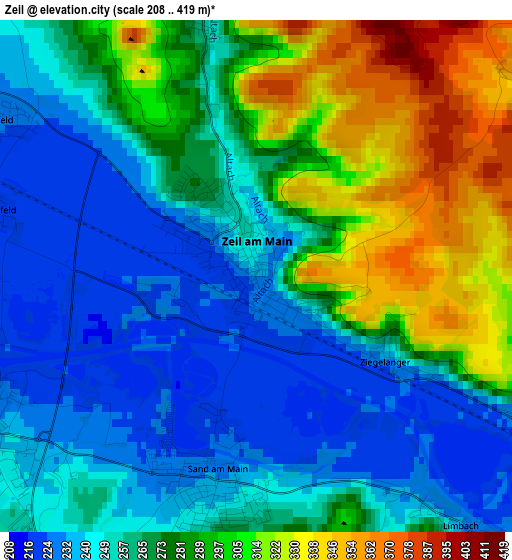
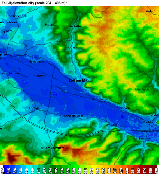
Below is the Elevation map of Zeil, which displays elevation range with different colors. Scale of the first map is from 208 to 419 m (682 to 1375 ft) with average elevation of 271 meters (=889 ft) [note 1]
These maps also provides idea of topography and contour of this city, they are displayed at different zoom levels. More info about maps, scale and edge coordinates you can find below images.
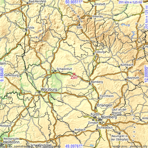
| \ | Map #1 | Map #2 | Topo.Map |
| Scale [m] | 208..419 m | 204..496 m | × |
| Scale [ft] | 682..1375 ft | 669..1627 ft | × |
| Average | 271 m = 889 ft | 296.5 m = 973 ft | × |
| Width | 6.28 km = 3.9 mi | 12.56 km = 7.8 mi | 201 km = 124.9 mi |
| Height | 6.28 km = 3.9 mi | 12.56 km = 7.8 mi | 201 km = 124.9 mi |
| ↑Max Latitude | 50.038093° | 50.06631° | 50.90511° |
| Latitude at center | 50.00986° | 50.00986° | 50.00986° |
| ↓Min Latitude | 49.98161° | 49.953343° | 49.09761° |
| ← Min Longitude | 10.550755° | 10.506809° | 9.18845° |
| Longitude center | 10.5947° | 10.5947° | 10.5947° |
| →Max Longitude | 10.638645° | 10.682591° | 12.00095° |
Nearby cities:
Cities around Zeil sort by population:
• Haßfurt elevation 233 m
6.3 km,  296°
296°
• Knetzgau 247 m
4.3 km,  227°
227°
• Eltmann 237 m
6.7 km,  129°
129°
• Ebelsbach 241 m
6.3 km,  115°
115°
• Sand 236 m
2.7 km,  192°
192°
• Wonfurt 219 m
9.2 km,  274°
274°
• Donnersdorf 252 m
13.6 km,  249°
249°
• Priesendorf 307 m
14.1 km,  143°
143°
• Kirchlauter 345 m
9.6 km,  66°
66°
• Stettfeld 247 m
10.1 km, 115°
• Lauter 277 m
14.4 km,  106°
106°
• Breitbrunn 294 m
7.6 km,  84°
84°
Multilingual:
 En español:
Zeil elevación 235 m.
 En France:
Zeil élévation 235 m.


Sources and notes:
- [note 1] Map square and city borders are not equal. Map elevation data is calculated only from area inside that square.
- [src 1] Elevation data from geonames database provided with same terms of usage.
- [src 2] The elevation map of Zeil is generated using elevation data from NASA's 3 arcsec (90m) resolution SRTM data.
- [src 3] Base (background) map © OpenStreetMap contributors tiles are generated by Geofabrik and OpenTopoMap.
Copyright & License:
This Zeil Elevation Map is licensed under CC BY-SA. You may reuse any part from this page, if you give a proper credit by linking to this URL:
 More info on terms of use page.