Český Dub elevation
Český Dub (Liberecký kraj, Okres Liberec), Czech Republic elevation is 328 meters and Český Dub elevation in feet is 1076 ft above sea level [src 1]. Český Dub is a populated place (feature code) with elevation that is 17 meters (56 ft) smaller than average city elevation in Czech Republic.
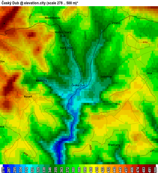
Below is the Elevation map of Český Dub, which displays elevation range with different colors. Scale of the first map is from 278 to 500 m (912 to 1640 ft) with average elevation of 387.4 meters (=1271 ft) [note 1]
These maps also provides idea of topography and contour of this city, they are displayed at different zoom levels. More info about maps, scale and edge coordinates you can find below images.
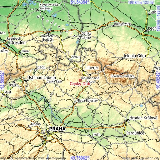
| \ | Map #1 | Topo.Map |
| Scale [m] | 278..500 m | × |
| Scale [ft] | 912..1640 ft | × |
| Average | 387.4 m = 1271 ft | × |
| Width | 6.19 km = 3.8 mi | 198.2 km = 123.2 mi |
| Height | 6.19 km = 3.8 mi | 198.2 km = 123.2 mi |
| ↑Max Latitude | 50.688389° | 51.54354° |
| Latitude at center | 50.66054° | 50.66054° |
| ↓Min Latitude | 50.632674° | 49.76062° |
| ← Min Longitude | 14.952225° | 13.58992° |
| Longitude center | 14.99617° | 14.99617° |
| →Max Longitude | 15.040115° | 16.40242° |
Nearby cities:
Cities around Český Dub sort by population:
• Liberec elevation 359 m
12.6 km,  19°
19°
• Jablonec nad Nisou 518 m
14.2 km,  60°
60°
• Turnov 255 m
13.9 km,  127°
127°
• Mnichovo Hradiště 241 m
14.9 km,  186°
186°
• Stráž pod Ralskem 315 m
14.5 km,  288°
288°
• Hodkovice nad Mohelkou 378 m
6.6 km,  84°
84°
• Stráž nad Nisou 362 m
14.7 km,  8°
8°
• Příšovice 241 m
11.1 km,  145°
145°
• Žďár 239 m
14.3 km,  155°
155°
• Malá Skála 326 m
14.1 km,  96°
96°
• Ohrazenice 288 m
11.5 km, 127°
• Osečná 374 m
6.5 km,  305°
305°
Multilingual:
 En español:
Český Dub elevación 328 m.
 En France:
Český Dub élévation 328 m.
 Auf Deutsch:
Böhmisch Aicha höhe über dem Meeresspiegel ist 328 m.

Sources and notes:
- [note 1] Map square and city borders are not equal. Map elevation data is calculated only from area inside that square.
- [src 1] Elevation data from geonames database provided with same terms of usage.
- [src 2] The elevation map of Český Dub is generated using elevation data from NASA's 3 arcsec (90m) resolution SRTM data.
- [src 3] Base (background) map © OpenStreetMap contributors tiles are generated by Geofabrik and OpenTopoMap.
Copyright & License:
This Český Dub Elevation Map is licensed under CC BY-SA. You may reuse any part from this page, if you give a proper credit by linking to this URL:
 More info on terms of use page.