Stráž pod Ralskem elevation
Stráž pod Ralskem (Liberecký kraj, Okres Česká Lípa), Czech Republic elevation is 315 meters and Stráž pod Ralskem elevation in feet is 1033 ft above sea level [src 1]. Stráž pod Ralskem is a populated place (feature code) with elevation that is 30 meters (98 ft) smaller than average city elevation in Czech Republic.
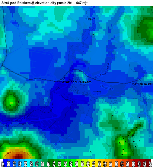
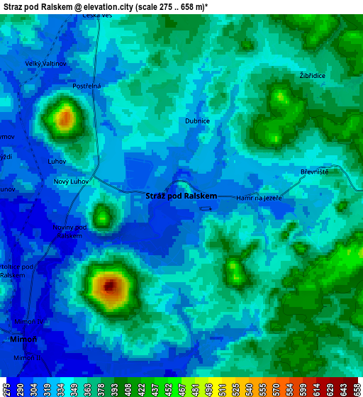
Below is the Elevation map of Stráž pod Ralskem, which displays elevation range with different colors. Scale of the first map is from 291 to 647 m (955 to 2123 ft) with average elevation of 338.7 meters (=1111 ft) [note 1]
These maps also provides idea of topography and contour of this city, they are displayed at different zoom levels. More info about maps, scale and edge coordinates you can find below images.
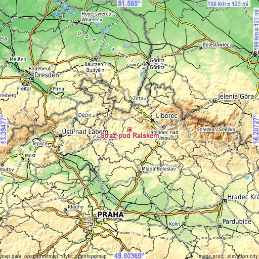
| \ | Map #1 | Map #2 | Topo.Map |
| Scale [m] | 291..647 m | 275..658 m | × |
| Scale [ft] | 955..2123 ft | 902..2159 ft | × |
| Average | 338.7 m = 1111 ft | 347.1 m = 1139 ft | × |
| Width | 6.19 km = 3.8 mi | 12.38 km = 7.7 mi | 198.1 km = 123.1 mi |
| Height | 6.19 km = 3.8 mi | 12.38 km = 7.7 mi | 198 km = 123 mi |
| ↑Max Latitude | 50.730624° | 50.758432° | 51.585° |
| Latitude at center | 50.7028° | 50.7028° | 50.7028° |
| ↓Min Latitude | 50.674959° | 50.647102° | 49.80369° |
| ← Min Longitude | 14.757075° | 14.713129° | 13.39477° |
| Longitude center | 14.80102° | 14.80102° | 14.80102° |
| →Max Longitude | 14.844965° | 14.888911° | 16.20727° |
Nearby cities:
Cities around Stráž pod Ralskem sort by population:
• Nový Bor elevation 371 m
18.3 km,  289°
289°
• Hrádek nad Nisou 253 m
17 km,  10°
10°
• Mimoň 281 m
7.3 km,  227°
227°
• Chrastava 297 m
17.3 km,  42°
42°
• Doksy 279 m
18.5 km,  213°
213°
• Cvikov 359 m
14.4 km,  304°
304°
• Jablonné v Podještědí 323 m
7.5 km,  337°
337°
• Zákupy 272 m
11.2 km,  259°
259°
• Český Dub 328 m
14.5 km,  108°
108°
• Stráž nad Nisou 362 m
18.7 km,  58°
58°
• Brniště 300 m
7.5 km, 293°
• Osečná 374 m
8.5 km,  95°
95°
Multilingual:
 En español:
Stráž pod Ralskem elevación 315 m.
 En France:
Stráž pod Ralskem élévation 315 m.
 Auf Deutsch:
Wartenberg am Rollberg höhe über dem Meeresspiegel ist 315 m.
 На русском:
Страж-под-Ральскем высота над уровнем моря 315 м
Sources and notes:
- [note 1] Map square and city borders are not equal. Map elevation data is calculated only from area inside that square.
- [src 1] Elevation data from geonames database provided with same terms of usage.
- [src 2] The elevation map of Stráž pod Ralskem is generated using elevation data from NASA's 3 arcsec (90m) resolution SRTM data.
- [src 3] Base (background) map © OpenStreetMap contributors tiles are generated by Geofabrik and OpenTopoMap.
Copyright & License:
This Stráž pod Ralskem Elevation Map is licensed under CC BY-SA. You may reuse any part from this page, if you give a proper credit by linking to this URL:
 More info on terms of use page.