Chrastava elevation
Chrastava (Liberecký kraj, Okres Liberec), Czech Republic elevation is 297 meters and Chrastava elevation in feet is 974 ft above sea level [src 1]. Chrastava is a populated place (feature code) with elevation that is 48 meters (157 ft) smaller than average city elevation in Czech Republic.
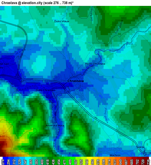
Below is the Elevation map of Chrastava, which displays elevation range with different colors. Scale of the first map is from 276 to 738 m (906 to 2421 ft) with average elevation of 373.5 meters (=1225 ft) [note 1]
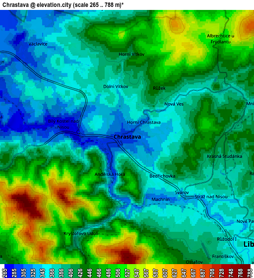
These maps also provides idea of topography and contour of this city, they are displayed at different zoom levels. More info about maps, scale and edge coordinates you can find below images.
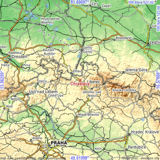
| \ | Map #1 | Map #2 | Topo.Map |
| Scale [m] | 276..738 m | 265..788 m | × |
| Scale [ft] | 906..2421 ft | 869..2585 ft | × |
| Average | 373.5 m = 1225 ft | 422.2 m = 1385 ft | × |
| Width | 6.17 km = 3.8 mi | 12.35 km = 7.7 mi | 197.6 km = 122.8 mi |
| Height | 6.17 km = 3.8 mi | 12.35 km = 7.7 mi | 197.6 km = 122.8 mi |
| ↑Max Latitude | 50.844686° | 50.872426° | 51.69697° |
| Latitude at center | 50.81693° | 50.81693° | 50.81693° |
| ↓Min Latitude | 50.789157° | 50.761368° | 49.91999° |
| ← Min Longitude | 14.924895° | 14.880949° | 13.56259° |
| Longitude center | 14.96884° | 14.96884° | 14.96884° |
| →Max Longitude | 15.012785° | 15.056731° | 16.37509° |
Nearby cities:
Cities around Chrastava sort by population:
• Liberec elevation 359 m
8.3 km,  132°
132°
• Frýdlant 296 m
14 km,  33°
33°
• Hrádek nad Nisou 253 m
9.6 km,  294°
294°
• Stráž pod Ralskem 315 m
17.3 km,  222°
222°
• Jablonné v Podještědí 323 m
15.7 km,  248°
248°
• Raspenava 325 m
14.1 km,  46°
46°
• Hejnice 377 m
16.4 km,  65°
65°
• Stráž nad Nisou 362 m
5 km, 125°
• Višňova 234 m
17.1 km,  13°
13°
• Janov nad Nisou 546 m
14.9 km,  109°
109°
• Mníšek 387 m
6.4 km,  75°
75°
• Osečná 374 m
14 km,  193°
193°
Multilingual:
 En español:
Chrastava elevación 297 m.
 En France:
Chrastava élévation 297 m.
 Auf Deutsch:
Chrastava höhe über dem Meeresspiegel ist 297 m.

Sources and notes:
- [note 1] Map square and city borders are not equal. Map elevation data is calculated only from area inside that square.
- [src 1] Elevation data from geonames database provided with same terms of usage.
- [src 2] The elevation map of Chrastava is generated using elevation data from NASA's 3 arcsec (90m) resolution SRTM data.
- [src 3] Base (background) map © OpenStreetMap contributors tiles are generated by Geofabrik and OpenTopoMap.
Copyright & License:
This Chrastava Elevation Map is licensed under CC BY-SA. You may reuse any part from this page, if you give a proper credit by linking to this URL:
 More info on terms of use page.