Jaroměřice elevation
Jaroměřice (Pardubický, Okres Svitavy), Czech Republic elevation is 364 meters and Jaroměřice elevation in feet is 1194 ft above sea level [src 1]. Jaroměřice is a populated place (feature code) with elevation that is 19 meters (62 ft) bigger than average city elevation in Czech Republic.
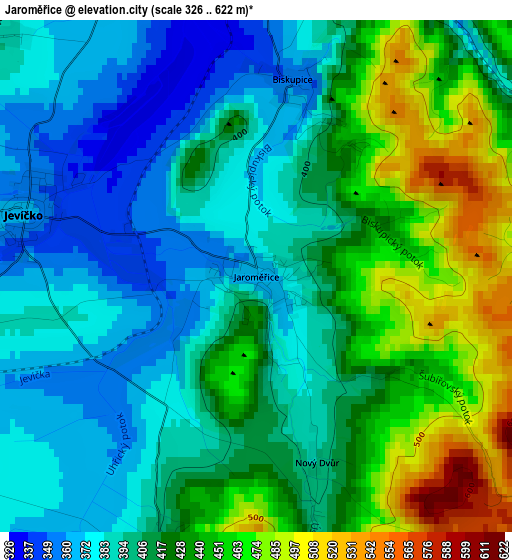
Below is the Elevation map of Jaroměřice, which displays elevation range with different colors. Scale of the first map is from 326 to 622 m (1070 to 2041 ft) with average elevation of 415.1 meters (=1362 ft) [note 1]
These maps also provides idea of topography and contour of this city, they are displayed at different zoom levels. More info about maps, scale and edge coordinates you can find below images.
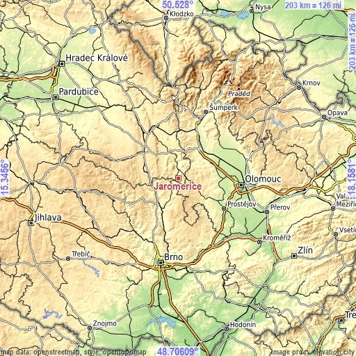
| \ | Map #1 | Topo.Map |
| Scale [m] | 326..622 m | × |
| Scale [ft] | 1070..2041 ft | × |
| Average | 415.1 m = 1362 ft | × |
| Width | 6.33 km = 3.9 mi | 202.6 km = 125.9 mi |
| Height | 6.33 km = 3.9 mi | 202.6 km = 125.9 mi |
| ↑Max Latitude | 49.654019° | 50.528° |
| Latitude at center | 49.62556° | 49.62556° |
| ↓Min Latitude | 49.597085° | 48.70609° |
| ← Min Longitude | 16.707905° | 15.3456° |
| Longitude center | 16.75185° | 16.75185° |
| →Max Longitude | 16.795795° | 18.1581° |
Nearby cities:
Cities around Jaroměřice sort by population:
• Moravská Třebová elevation 364 m
16 km,  336°
336°
• Boskovice 386 m
16.7 km,  203°
203°
• Letovice 330 m
15.5 km,  235°
235°
• Velké Opatovice 379 m
5.4 km,  254°
254°
• Konice 426 m
10.6 km,  111°
111°
• Jevíčko 363 m
3 km,  284°
284°
• Městečko Trnávka 319 m
9.5 km,  349°
349°
• Bouzov 384 m
13.4 km,  49°
49°
• Brněnec 377 m
16.6 km,  270°
270°
• Přemyslovice 411 m
16.6 km,  117°
117°
• Protivanov 665 m
16.9 km,  158°
158°
• Horní Štěpánov 596 m
9 km, 161°
Multilingual:
 En español:
Jaroměřice elevación 364 m.
 En France:
Jaroměřice élévation 364 m.
 Auf Deutsch:
Jaroměřice höhe über dem Meeresspiegel ist 364 m.

Sources and notes:
- [note 1] Map square and city borders are not equal. Map elevation data is calculated only from area inside that square.
- [src 1] Elevation data from geonames database provided with same terms of usage.
- [src 2] The elevation map of Jaroměřice is generated using elevation data from NASA's 3 arcsec (90m) resolution SRTM data.
- [src 3] Base (background) map © OpenStreetMap contributors tiles are generated by Geofabrik and OpenTopoMap.
Copyright & License:
This Jaroměřice Elevation Map is licensed under CC BY-SA. You may reuse any part from this page, if you give a proper credit by linking to this URL:
 More info on terms of use page.