Městečko Trnávka elevation
Městečko Trnávka (Pardubický, Okres Svitavy), Czech Republic elevation is 319 meters and Městečko Trnávka elevation in feet is 1047 ft above sea level [src 1]. Městečko Trnávka is a populated place (feature code) with elevation that is 26 meters (85 ft) smaller than average city elevation in Czech Republic.
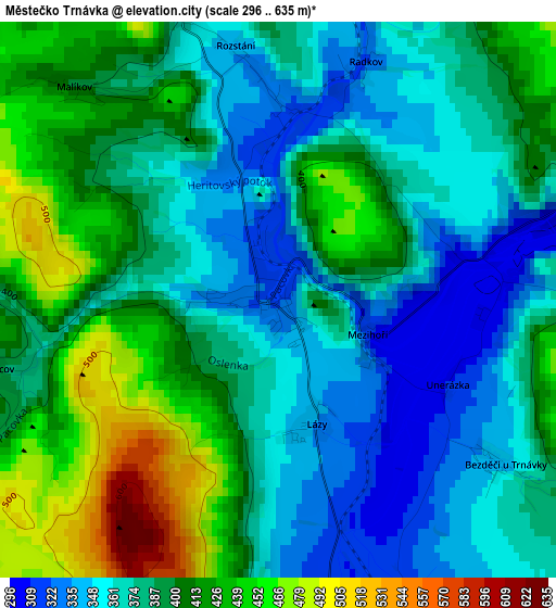
Below is the Elevation map of Městečko Trnávka, which displays elevation range with different colors. Scale of the first map is from 296 to 635 m (971 to 2083 ft) with average elevation of 390.1 meters (=1280 ft) [note 1]
These maps also provides idea of topography and contour of this city, they are displayed at different zoom levels. More info about maps, scale and edge coordinates you can find below images.
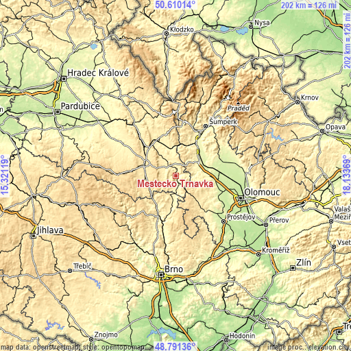
| \ | Map #1 | Topo.Map |
| Scale [m] | 296..635 m | × |
| Scale [ft] | 971..2083 ft | × |
| Average | 390.1 m = 1280 ft | × |
| Width | 6.32 km = 3.9 mi | 202.2 km = 125.6 mi |
| Height | 6.32 km = 3.9 mi | 202.2 km = 125.6 mi |
| ↑Max Latitude | 49.73767° | 50.61014° |
| Latitude at center | 49.70926° | 49.70926° |
| ↓Min Latitude | 49.680834° | 48.79136° |
| ← Min Longitude | 16.683495° | 15.32119° |
| Longitude center | 16.72744° | 16.72744° |
| →Max Longitude | 16.771385° | 18.13369° |
Nearby cities:
Cities around Městečko Trnávka sort by population:
• Moravská Třebová elevation 364 m
7.1 km,  320°
320°
• Mohelnice 278 m
15.7 km,  61°
61°
• Velké Opatovice 379 m
11.3 km,  197°
197°
• Loštice 260 m
15 km,  74°
74°
• Konice 426 m
17.6 km,  138°
138°
• Jevíčko 363 m
8.6 km,  187°
187°
• Březová nad Svitavou 382 m
16.7 km,  244°
244°
• Bouzov 384 m
11.9 km,  92°
92°
• Brněnec 377 m
17.4 km, 238°
• Jaroměřice 364 m
9.5 km,  169°
169°
• Kunčina 374 m
11.9 km, 322°
• Moravičany 249 m
17.6 km, 72°
Multilingual:
 En español:
Městečko Trnávka elevación 319 m.
 En France:
Městečko Trnávka élévation 319 m.
 Auf Deutsch:
Městečko Trnávka höhe über dem Meeresspiegel ist 319 m.

Sources and notes:
- [note 1] Map square and city borders are not equal. Map elevation data is calculated only from area inside that square.
- [src 1] Elevation data from geonames database provided with same terms of usage.
- [src 2] The elevation map of Městečko Trnávka is generated using elevation data from NASA's 3 arcsec (90m) resolution SRTM data.
- [src 3] Base (background) map © OpenStreetMap contributors tiles are generated by Geofabrik and OpenTopoMap.
Copyright & License:
This Městečko Trnávka Elevation Map is licensed under CC BY-SA. You may reuse any part from this page, if you give a proper credit by linking to this URL:
 More info on terms of use page.