Protivanov elevation
Protivanov (Olomoucký, Okres Prostějov), Czech Republic elevation is 665 meters and Protivanov elevation in feet is 2182 ft above sea level [src 1]. Protivanov is a populated place (feature code) with elevation that is 320 meters (1050 ft) bigger than average city elevation in Czech Republic.
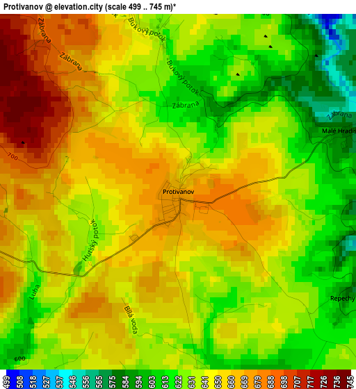
Below is the Elevation map of Protivanov, which displays elevation range with different colors. Scale of the first map is from 499 to 745 m (1637 to 2444 ft) with average elevation of 642.5 meters (=2108 ft) [note 1]
These maps also provides idea of topography and contour of this city, they are displayed at different zoom levels. More info about maps, scale and edge coordinates you can find below images.
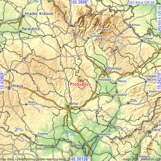
| \ | Map #1 | Topo.Map |
| Scale [m] | 499..745 m | × |
| Scale [ft] | 1637..2444 ft | × |
| Average | 642.5 m = 2108 ft | × |
| Width | 6.35 km = 3.9 mi | 203.2 km = 126.3 mi |
| Height | 6.35 km = 3.9 mi | 203.2 km = 126.3 mi |
| ↑Max Latitude | 49.512051° | 50.3886° |
| Latitude at center | 49.48351° | 49.48351° |
| ↓Min Latitude | 49.454952° | 48.56138° |
| ← Min Longitude | 16.791995° | 15.42969° |
| Longitude center | 16.83594° | 16.83594° |
| →Max Longitude | 16.879885° | 18.24219° |
Nearby cities:
Cities around Protivanov sort by population:
• Boskovice elevation 386 m
12.7 km,  272°
272°
• Rájec-Jestřebí 295 m
16.4 km,  240°
240°
• Konice 426 m
12.5 km,  17°
17°
• Kostelec na Hané 241 m
16.4 km,  78°
78°
• Plumlov 307 m
13.1 km,  98°
98°
• Mostkovice 254 m
15.7 km,  94°
94°
• Přemyslovice 411 m
11.9 km,  46°
46°
• Doubravice nad Svitavou 313 m
15.8 km,  250°
250°
• Ptení 326 m
9.6 km,  70°
70°
• Ostrov u Macochy 503 m
12.4 km,  205°
205°
• Lipovec 552 m
11.3 km,  191°
191°
• Horní Štěpánov 596 m
8 km,  335°
335°
Multilingual:
 En español:
Protivanov elevación 665 m.
 En France:
Protivanov élévation 665 m.
 Auf Deutsch:
Protivanov höhe über dem Meeresspiegel ist 665 m.

Sources and notes:
- [note 1] Map square and city borders are not equal. Map elevation data is calculated only from area inside that square.
- [src 1] Elevation data from geonames database provided with same terms of usage.
- [src 2] The elevation map of Protivanov is generated using elevation data from NASA's 3 arcsec (90m) resolution SRTM data.
- [src 3] Base (background) map © OpenStreetMap contributors tiles are generated by Geofabrik and OpenTopoMap.
Copyright & License:
This Protivanov Elevation Map is licensed under CC BY-SA. You may reuse any part from this page, if you give a proper credit by linking to this URL:
 More info on terms of use page.