Armero-Guyabal elevation
Armero-Guyabal (Tolima, Armero), Colombia elevation is 341 meters and Armero-Guyabal elevation in feet is 1119 ft above sea level [src 1]. Armero-Guyabal is a populated locality (feature code) with elevation that is 808 meters (2651 ft) smaller than average city elevation in Colombia.
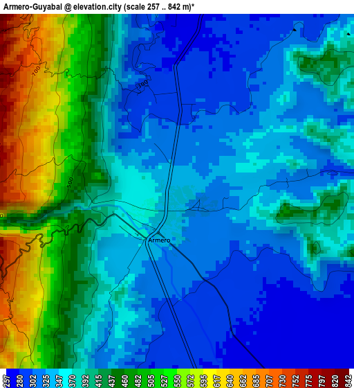
Below is the Elevation map of Armero-Guyabal, which displays elevation range with different colors. Scale of the first map is from 257 to 842 m (843 to 2762 ft) with average elevation of 389.5 meters (=1278 ft) [note 1]
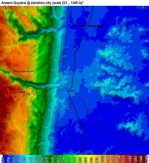
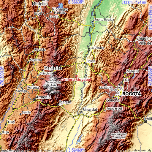
These maps also provides idea of topography and contour of this city, they are displayed at different zoom levels. More info about maps, scale and edge coordinates you can find below images.
| \ | Map #1 | Map #2 | Topo.Map |
| Scale [m] | 257..842 m | 231..1349 m | × |
| Scale [ft] | 843..2762 ft | 758..4426 ft | × |
| Average | 389.5 m = 1278 ft | 502.6 m = 1649 ft | × |
| Width | 9.74 km = 6.1 mi | 19.47 km = 12.1 mi | 311.5 km = 193.6 mi |
| Height | 9.74 km = 6.1 mi | 19.47 km = 12.1 mi | 311.5 km = 193.6 mi |
| ↑Max Latitude | 5.010789° | 5.054565° | 6.36635° |
| Latitude at center | 4.96701° | 4.96701° | 4.96701° |
| ↓Min Latitude | 4.923228° | 4.879444° | 3.56469° |
| ← Min Longitude | -74.946885° | -74.990831° | -76.30919° |
| Longitude center | -74.90294° | -74.90294° | -74.90294° |
| →Max Longitude | -74.858995° | -74.815049° | -73.49669° |
Nearby cities:
Cities around Armero-Guyabal sort by population:
• Líbano elevation 1575 m
18.4 km,  254°
254°
• San Sebastián de Mariquita 485 m
25.8 km,  2°
2°
• Lérida 345 m
11.7 km,  183°
183°
• Fresno 1467 m
25.4 km,  324°
324°
• Junín 1235 m
24 km,  211°
211°
• Guayabal 280 m
7.3 km,  14°
14°
• Falan 954 m
18.3 km,  342°
342°
• Ambalema 231 m
25.6 km,  142°
142°
• Villahermosa 2046 m
24.6 km,  286°
286°
• Palocabildo 1451 m
20.9 km, 322°
• Frías 1321 m
13.6 km,  300°
300°
• Beltrán 231 m
25.6 km, 135°
Multilingual:
 En español:
Armero-Guyabal elevación 341 m.
 En France:
Armero-Guyabal élévation 341 m.
 Auf Deutsch:
Armero-Guyabal höhe über dem Meeresspiegel ist 341 m.

Sources and notes:
- [note 1] Map square and city borders are not equal. Map elevation data is calculated only from area inside that square.
- [src 1] Elevation data from geonames database provided with same terms of usage.
- [src 2] The elevation map of Armero-Guyabal is generated using elevation data from NASA's 3 arcsec (90m) resolution SRTM data.
- [src 3] Base (background) map © OpenStreetMap contributors tiles are generated by Geofabrik and OpenTopoMap.
Copyright & License:
This Armero-Guyabal Elevation Map is licensed under CC BY-SA. You may reuse any part from this page, if you give a proper credit by linking to this URL:
 More info on terms of use page.