Guayabal elevation
Guayabal (Tolima, Armero), Colombia elevation is 280 meters and Guayabal elevation in feet is 919 ft above sea level [src 1]. Guayabal is a seat of a second-order administrative division (feature code) with elevation that is 869 meters (2851 ft) smaller than average city elevation in Colombia.
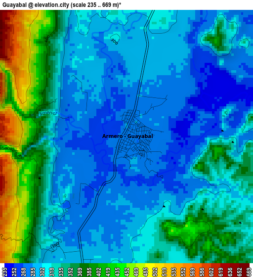
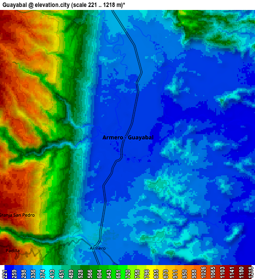
Below is the Elevation map of Guayabal, which displays elevation range with different colors. Scale of the first map is from 235 to 669 m (771 to 2195 ft) with average elevation of 328.2 meters (=1077 ft) [note 1]
These maps also provides idea of topography and contour of this city, they are displayed at different zoom levels. More info about maps, scale and edge coordinates you can find below images.
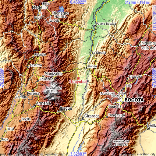
| \ | Map #1 | Map #2 | Topo.Map |
| Scale [m] | 235..669 m | 221..1218 m | × |
| Scale [ft] | 771..2195 ft | 725..3996 ft | × |
| Average | 328.2 m = 1077 ft | 466.9 m = 1532 ft | × |
| Width | 9.73 km = 6 mi | 19.47 km = 12.1 mi | 311.5 km = 193.6 mi |
| Height | 9.73 km = 6 mi | 19.47 km = 12.1 mi | 311.5 km = 193.6 mi |
| ↑Max Latitude | 5.074805° | 5.118576° | 6.43022° |
| Latitude at center | 5.03103° | 5.03103° | 5.03103° |
| ↓Min Latitude | 4.987253° | 4.943472° | 3.62883° |
| ← Min Longitude | -74.930775° | -74.974721° | -76.29308° |
| Longitude center | -74.88683° | -74.88683° | -74.88683° |
| →Max Longitude | -74.842885° | -74.798939° | -73.48058° |
Nearby cities:
Cities around Guayabal sort by population:
• Líbano elevation 1575 m
22.9 km,  238°
238°
• Honda 200 m
25.9 km,  40°
40°
• San Sebastián de Mariquita 485 m
18.7 km,  357°
357°
• Lérida 345 m
18.9 km,  187°
187°
• Fresno 1467 m
21.4 km,  309°
309°
• Armero-Guyabal 341 m
7.3 km, 194°
• Falan 954 m
12.6 km,  325°
325°
• Villahermosa 2046 m
25.4 km,  269°
269°
• Palocabildo 1451 m
17.3 km,  303°
303°
• Casabianca 2036 m
26.4 km,  281°
281°
• Frías 1321 m
13.5 km, 269°
• Puerto Bogotá 225 m
25.8 km, 43°
Multilingual:
 En español:
Guayabal elevación 280 m.
 En France:
Guayabal élévation 280 m.
 Auf Deutsch:
Guayabal höhe über dem Meeresspiegel ist 280 m.

Sources and notes:
- [note 1] Map square and city borders are not equal. Map elevation data is calculated only from area inside that square.
- [src 1] Elevation data from geonames database provided with same terms of usage.
- [src 2] The elevation map of Guayabal is generated using elevation data from NASA's 3 arcsec (90m) resolution SRTM data.
- [src 3] Base (background) map © OpenStreetMap contributors tiles are generated by Geofabrik and OpenTopoMap.
Copyright & License:
This Guayabal Elevation Map is licensed under CC BY-SA. You may reuse any part from this page, if you give a proper credit by linking to this URL:
 More info on terms of use page.