San Sebastián de Mariquita elevation
San Sebastián de Mariquita (Tolima, Municipio de San Sebastián de Mariquita), Colombia elevation is 485 meters and San Sebastián de Mariquita elevation in feet is 1591 ft above sea level [src 1]. San Sebastián de Mariquita is a seat of a second-order administrative division (feature code) with elevation that is 664 meters (2178 ft) smaller than average city elevation in Colombia.
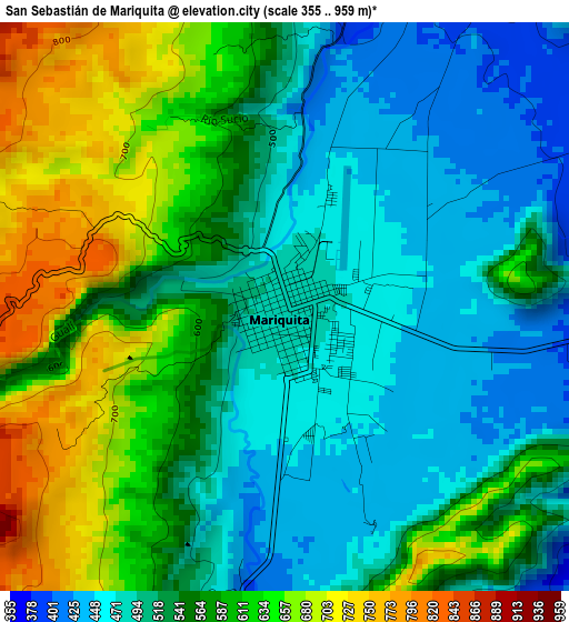
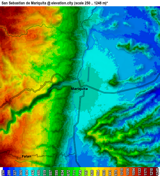
Below is the Elevation map of San Sebastián de Mariquita, which displays elevation range with different colors. Scale of the first map is from 355 to 959 m (1165 to 3146 ft) with average elevation of 551.5 meters (=1809 ft) [note 1]
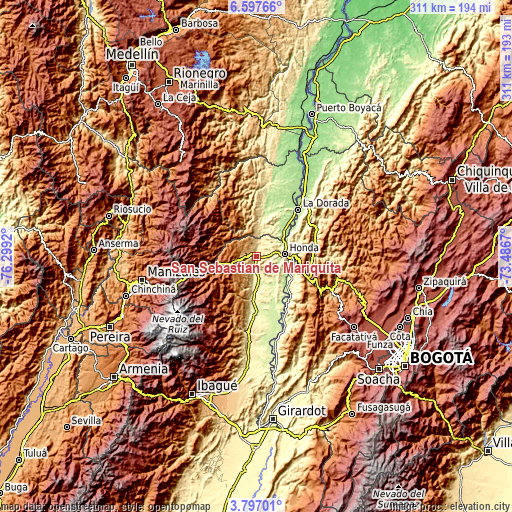
These maps also provides idea of topography and contour of this city, they are displayed at different zoom levels. More info about maps, scale and edge coordinates you can find below images.
| \ | Map #1 | Map #2 | Topo.Map |
| Scale [m] | 355..959 m | 250..1248 m | × |
| Scale [ft] | 1165..3146 ft | 820..4094 ft | × |
| Average | 551.5 m = 1809 ft | 620 m = 2034 ft | × |
| Width | 9.73 km = 6 mi | 19.46 km = 12.1 mi | 311.4 km = 193.5 mi |
| Height | 9.73 km = 6 mi | 19.46 km = 12.1 mi | 311.4 km = 193.5 mi |
| ↑Max Latitude | 5.242653° | 5.286413° | 6.59766° |
| Latitude at center | 5.19889° | 5.19889° | 5.19889° |
| ↓Min Latitude | 5.155124° | 5.111355° | 3.79701° |
| ← Min Longitude | -74.936895° | -74.980841° | -76.2992° |
| Longitude center | -74.89295° | -74.89295° | -74.89295° |
| →Max Longitude | -74.849005° | -74.805059° | -73.4867° |
Nearby cities:
Cities around San Sebastián de Mariquita sort by population:
• Honda elevation 200 m
17.4 km,  86°
86°
• Padua 2041 m
28.3 km,  255°
255°
• Fresno 1467 m
16.7 km,  252°
252°
• Armero-Guyabal 341 m
25.8 km,  182°
182°
• Marquetalia 1554 m
21 km,  301°
301°
• Guayabal 280 m
18.7 km, 177°
• Falan 954 m
10.6 km,  217°
217°
• Victoria 712 m
13.2 km,  351°
351°
• Palocabildo 1451 m
16.5 km,  236°
236°
• Frías 1321 m
22.8 km,  214°
214°
• Puerto Bogotá 225 m
18.3 km, 89°
• Samaná 1463 m
26.2 km,  335°
335°
Multilingual:
 En español:
San Sebastián de Mariquita elevación 485 m.
 En France:
San Sebastián de Mariquita élévation 485 m.
 Auf Deutsch:
San Sebastián de Mariquita höhe über dem Meeresspiegel ist 485 m.
 На русском:
San Sebastián de Mariquita высота над уровнем моря 485 м
Sources and notes:
- [note 1] Map square and city borders are not equal. Map elevation data is calculated only from area inside that square.
- [src 1] Elevation data from geonames database provided with same terms of usage.
- [src 2] The elevation map of San Sebastián de Mariquita is generated using elevation data from NASA's 3 arcsec (90m) resolution SRTM data.
- [src 3] Base (background) map © OpenStreetMap contributors tiles are generated by Geofabrik and OpenTopoMap.
Copyright & License:
This San Sebastián de Mariquita Elevation Map is licensed under CC BY-SA. You may reuse any part from this page, if you give a proper credit by linking to this URL:
 More info on terms of use page.