Honda elevation
Honda (Tolima), Colombia elevation is 200 meters and Honda elevation in feet is 656 ft above sea level [src 1]. Honda is a seat of a second-order administrative division (feature code) with elevation that is 949 meters (3114 ft) smaller than average city elevation in Colombia.
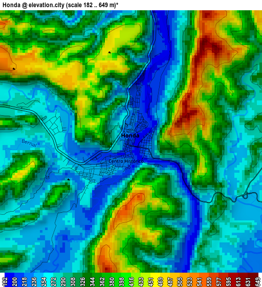
Below is the Elevation map of Honda, which displays elevation range with different colors. Scale of the first map is from 182 to 649 m (597 to 2129 ft) with average elevation of 326 meters (=1070 ft) [note 1]
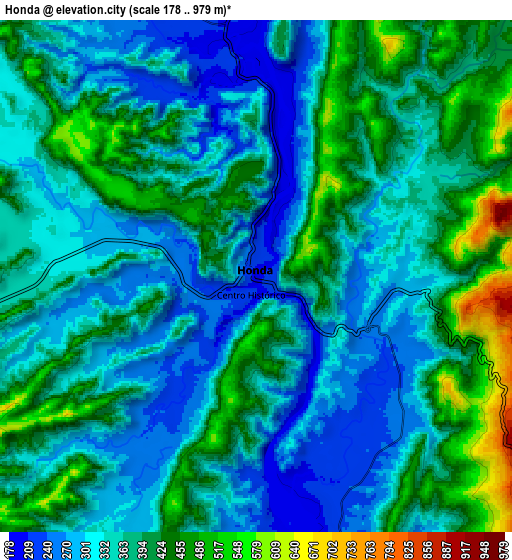
These maps also provides idea of topography and contour of this city, they are displayed at different zoom levels. More info about maps, scale and edge coordinates you can find below images.
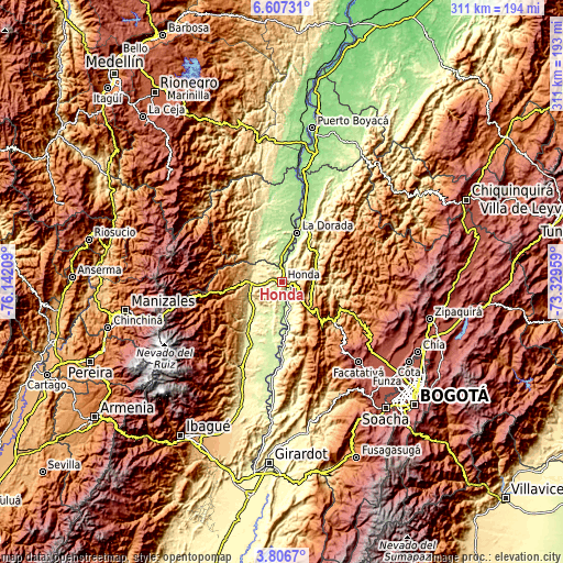
| \ | Map #1 | Map #2 | Topo.Map |
| Scale [m] | 182..649 m | 178..979 m | × |
| Scale [ft] | 597..2129 ft | 584..3212 ft | × |
| Average | 326 m = 1070 ft | 366.3 m = 1202 ft | × |
| Width | 9.73 km = 6 mi | 19.46 km = 12.1 mi | 311.4 km = 193.5 mi |
| Height | 9.73 km = 6 mi | 19.46 km = 12.1 mi | 311.4 km = 193.5 mi |
| ↑Max Latitude | 5.252322° | 5.296082° | 6.60731° |
| Latitude at center | 5.20856° | 5.20856° | 5.20856° |
| ↓Min Latitude | 5.164795° | 5.121026° | 3.8067° |
| ← Min Longitude | -74.779785° | -74.823731° | -76.14209° |
| Longitude center | -74.73584° | -74.73584° | -74.73584° |
| →Max Longitude | -74.691895° | -74.647949° | -73.32959° |
Nearby cities:
Cities around Honda sort by population:
• La Dorada elevation 176 m
27.8 km,  16°
16°
• San Sebastián de Mariquita 485 m
17.4 km,  266°
266°
• Guaduas 993 m
22.2 km,  135°
135°
• Puerto Salgar 177 m
29.7 km, 17°
• Guayabal 280 m
25.9 km,  220°
220°
• Falan 954 m
25.7 km,  248°
248°
• Victoria 712 m
22.8 km,  301°
301°
• Cachipay 389 m
19.8 km,  70°
70°
• Útica 503 m
28.3 km,  94°
94°
• Puerto Bogotá 225 m
1.3 km, 135°
• Granada 1584 m
24.5 km,  130°
130°
• Quebradanegra 1356 m
30.1 km,  109°
109°
Multilingual:
 En español:
Honda elevación 200 m.
 En France:
Honda élévation 200 m.


Sources and notes:
- [note 1] Map square and city borders are not equal. Map elevation data is calculated only from area inside that square.
- [src 1] Elevation data from geonames database provided with same terms of usage.
- [src 2] The elevation map of Honda is generated using elevation data from NASA's 3 arcsec (90m) resolution SRTM data.
- [src 3] Base (background) map © OpenStreetMap contributors tiles are generated by Geofabrik and OpenTopoMap.
Copyright & License:
This Honda Elevation Map is licensed under CC BY-SA. You may reuse any part from this page, if you give a proper credit by linking to this URL:
 More info on terms of use page.