Granada elevation
Granada (Cundinamarca, Guaduas), Colombia elevation is 1584 meters and Granada elevation in feet is 5197 ft above sea level [src 1]. Granada is a populated place (feature code) with elevation that is 435 meters (1427 ft) bigger than average city elevation in Colombia.
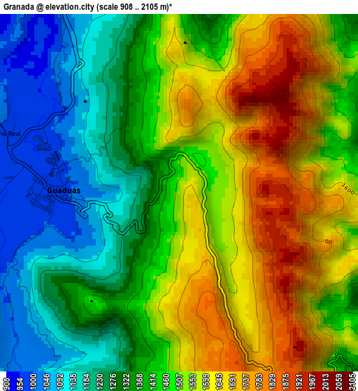
Below is the Elevation map of Granada, which displays elevation range with different colors. Scale of the first map is from 908 to 2105 m (2979 to 6906 ft) with average elevation of 1443.1 meters (=4735 ft) [note 1]
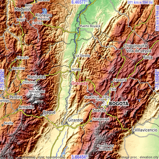
These maps also provides idea of topography and contour of this city, they are displayed at different zoom levels. More info about maps, scale and edge coordinates you can find below images.
| \ | Map #1 | Topo.Map |
| Scale [m] | 908..2105 m | × |
| Scale [ft] | 2979..6906 ft | × |
| Average | 1443.1 m = 4735 ft | × |
| Width | 9.73 km = 6 mi | 311.5 km = 193.6 mi |
| Height | 9.73 km = 6 mi | 311.5 km = 193.6 mi |
| ↑Max Latitude | 5.110442° | 6.46577° |
| Latitude at center | 5.06667° | 5.06667° |
| ↓Min Latitude | 5.022895° | 3.66454° |
| ← Min Longitude | -74.610615° | -75.97292° |
| Longitude center | -74.56667° | -74.56667° |
| →Max Longitude | -74.522725° | -73.16042° |
Nearby cities:
Cities around Granada sort by population:
• Villeta elevation 810 m
12.3 km,  121°
121°
• Guaduas 993 m
3.1 km,  270°
270°
• Cachipay 389 m
22.2 km,  0°
0°
• Sasaima 1141 m
18.3 km,  127°
127°
• Útica 503 m
16.4 km,  35°
35°
• Nocaima 1108 m
20.2 km,  89°
89°
• Vianí 1491 m
21.4 km,  178°
178°
• Puerto Bogotá 225 m
23.2 km,  309°
309°
• Chaguaní 1030 m
13.5 km,  192°
192°
• Quebradanegra 1356 m
11.2 km,  59°
59°
• Nimaima 1107 m
21.2 km,  71°
71°
• Bituima 1364 m
21.8 km,  171°
171°
Multilingual:
 En español:
Granada elevación 1584 m.
 En France:
Granada élévation 1584 m.
 Auf Deutsch:
Granada höhe über dem Meeresspiegel ist 1584 m.

Sources and notes:
- [note 1] Map square and city borders are not equal. Map elevation data is calculated only from area inside that square.
- [src 1] Elevation data from geonames database provided with same terms of usage.
- [src 2] The elevation map of Granada is generated using elevation data from NASA's 3 arcsec (90m) resolution SRTM data.
- [src 3] Base (background) map © OpenStreetMap contributors tiles are generated by Geofabrik and OpenTopoMap.
Copyright & License:
This Granada Elevation Map is licensed under CC BY-SA. You may reuse any part from this page, if you give a proper credit by linking to this URL:
 More info on terms of use page.