Quebradanegra elevation
Quebradanegra (Cundinamarca), Colombia elevation is 1356 meters and Quebradanegra elevation in feet is 4449 ft above sea level [src 1]. Quebradanegra is a seat of a second-order administrative division (feature code) with elevation that is 207 meters (679 ft) bigger than average city elevation in Colombia.
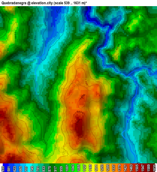
Below is the Elevation map of Quebradanegra, which displays elevation range with different colors. Scale of the first map is from 539 to 1631 m (1768 to 5351 ft) with average elevation of 982.8 meters (=3224 ft) [note 1]
These maps also provides idea of topography and contour of this city, they are displayed at different zoom levels. More info about maps, scale and edge coordinates you can find below images.
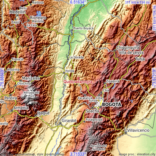
| \ | Map #1 | Topo.Map |
| Scale [m] | 539..1631 m | × |
| Scale [ft] | 1768..5351 ft | × |
| Average | 982.8 m = 3224 ft | × |
| Width | 9.73 km = 6 mi | 311.4 km = 193.5 mi |
| Height | 9.73 km = 6 mi | 311.5 km = 193.6 mi |
| ↑Max Latitude | 5.161139° | 6.51634° |
| Latitude at center | 5.11737° | 5.11737° |
| ↓Min Latitude | 5.073598° | 3.71533° |
| ← Min Longitude | -74.523385° | -75.88569° |
| Longitude center | -74.47944° | -74.47944° |
| →Max Longitude | -74.435495° | -73.07319° |
Nearby cities:
Cities around Quebradanegra sort by population:
• Villeta elevation 810 m
12.1 km,  176°
176°
• Guaduas 993 m
14 km,  246°
246°
• La Vega 1141 m
19.9 km,  130°
130°
• Cachipay 389 m
19.2 km,  329°
329°
• Sasaima 1141 m
17.4 km,  163°
163°
• Útica 503 m
7.8 km,  358°
358°
• Nocaima 1108 m
11.9 km,  118°
118°
• Vergara 1553 m
14.8 km,  89°
89°
• La Peña 1254 m
13.1 km,  46°
46°
• Chaguaní 1030 m
22.7 km,  213°
213°
• Granada 1584 m
11.2 km,  239°
239°
• Nimaima 1107 m
10.5 km,  84°
84°
Multilingual:
 En español:
Quebradanegra elevación 1356 m.
 En France:
Quebradanegra élévation 1356 m.
 Auf Deutsch:
Quebradanegra höhe über dem Meeresspiegel ist 1356 m.

Sources and notes:
- [note 1] Map square and city borders are not equal. Map elevation data is calculated only from area inside that square.
- [src 1] Elevation data from geonames database provided with same terms of usage.
- [src 2] The elevation map of Quebradanegra is generated using elevation data from NASA's 3 arcsec (90m) resolution SRTM data.
- [src 3] Base (background) map © OpenStreetMap contributors tiles are generated by Geofabrik and OpenTopoMap.
Copyright & License:
This Quebradanegra Elevation Map is licensed under CC BY-SA. You may reuse any part from this page, if you give a proper credit by linking to this URL:
 More info on terms of use page.