La Vega elevation
La Vega (Cundinamarca), Colombia elevation is 1141 meters and La Vega elevation in feet is 3743 ft above sea level [src 1]. La Vega is a populated place (feature code) with elevation that is 8 meters (26 ft) smaller than average city elevation in Colombia.
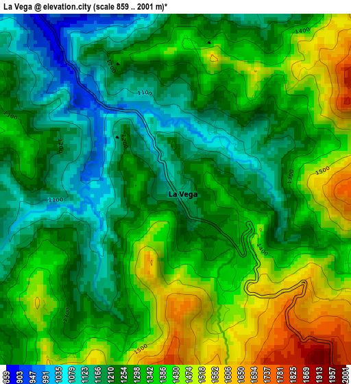
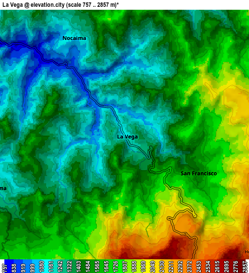
Below is the Elevation map of La Vega, which displays elevation range with different colors. Scale of the first map is from 859 to 2001 m (2818 to 6565 ft) with average elevation of 1309.9 meters (=4298 ft) [note 1]
These maps also provides idea of topography and contour of this city, they are displayed at different zoom levels. More info about maps, scale and edge coordinates you can find below images.
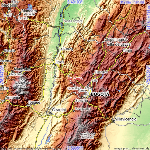
| \ | Map #1 | Map #2 | Topo.Map |
| Scale [m] | 859..2001 m | 757..2857 m | × |
| Scale [ft] | 2818..6565 ft | 2484..9373 ft | × |
| Average | 1309.9 m = 4298 ft | 1519.8 m = 4986 ft | × |
| Width | 9.74 km = 6.1 mi | 19.47 km = 12.1 mi | 311.5 km = 193.6 mi |
| Height | 9.74 km = 6.1 mi | 19.47 km = 12.1 mi | 311.5 km = 193.6 mi |
| ↑Max Latitude | 5.045547° | 5.08932° | 6.40103° |
| Latitude at center | 5.00177° | 5.00177° | 5.00177° |
| ↓Min Latitude | 4.957991° | 4.914208° | 3.59951° |
| ← Min Longitude | -74.385685° | -74.429631° | -75.74799° |
| Longitude center | -74.34174° | -74.34174° | -74.34174° |
| →Max Longitude | -74.297795° | -74.253849° | -72.93549° |
Nearby cities:
Cities around La Vega sort by population:
• Villeta elevation 810 m
14.5 km,  273°
273°
• El Rosal 2612 m
18.8 km,  151°
151°
• Subachoque 2651 m
20.5 km,  114°
114°
• Sasaima 1141 m
11 km,  249°
249°
• San Francisco 1458 m
6 km,  115°
115°
• Nocaima 1108 m
8.7 km,  326°
326°
• Vergara 1553 m
13 km,  358°
358°
• Supatá 1778 m
13.3 km,  60°
60°
• Albán 2242 m
17.5 km,  217°
217°
• Guayabal de Síquima 1604 m
19.6 km,  225°
225°
• Quebradanegra 1356 m
19.9 km,  310°
310°
• Nimaima 1107 m
14.6 km,  340°
340°
Multilingual:
 En español:
La Vega elevación 1141 m.
 En France:
La Vega élévation 1141 m.
 Auf Deutsch:
La Vega höhe über dem Meeresspiegel ist 1141 m.

Sources and notes:
- [note 1] Map square and city borders are not equal. Map elevation data is calculated only from area inside that square.
- [src 1] Elevation data from geonames database provided with same terms of usage.
- [src 2] The elevation map of La Vega is generated using elevation data from NASA's 3 arcsec (90m) resolution SRTM data.
- [src 3] Base (background) map © OpenStreetMap contributors tiles are generated by Geofabrik and OpenTopoMap.
Copyright & License:
This La Vega Elevation Map is licensed under CC BY-SA. You may reuse any part from this page, if you give a proper credit by linking to this URL:
 More info on terms of use page.